Huaping geodata
Huaping (Guizhou) is a seat of a fourth-order administrative division; located in China in Asia/Shanghai (GMT+8) time zone. In our database, there are 1268 cities with bigger population. Compared to other cities in China, 73.8% of cities are located further ↑North; 81.3% of cities are located further →East and 80.5% of cities have lower elevation than Huaping. Note1


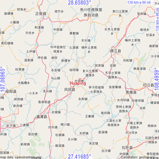
Huaping GPS coordinates[2]
28° 2' 21.228" North, 107° 47' 33.972" East
| Map corner | latitude | longitude |
|---|---|---|
| Upper-left | 28.65803°, | 107.08965° |
| Center: | 28.03923°, | 107.79277° |
| Lower-right: | 27.41685°, | 108.4959° |
| Map W x H: | 138×138 km | = 85.7×85.7mi |
| max Lat: | 53.31946° ⇑73.8% North |
| Huaping: | 28.03923° |
| min Lat: | ⇓26.2% South 18.22056° |
| min Long | Huaping | max Long |
| 75.07348° | 107.79277° | 134.28917° |
| W 18.7%⇐ | ⇒81.3% E |
Elevation
Elevation of Huaping is 720 m = 2362 ft, and this is 235.2 m = 772 ft above average elevation for this country.
| Max E: |
5622 m = 18445 ft | 19.5% |
| Huaping | 720 m 2362 ft | |
| Avg. | 484.8 m = 1591 ft | |
Min E: |
-3 m = -10 ft | 80.5% |
See also: China elevation on elevation.city.
Geographical zone
Huaping is located in North temperate zone (between Tropic of Cancer and the Arctic Circle). Distance of this Northern Tropic circle is 511.8 km =318 mi to South.| Distance of | km | miles | from Huaping |
|---|---|---|---|
| North Pole | 6889.4 | 4280.9 | to North |
| Arctic Circle | 4283.5 | 2661.6 | to North |
| Tropic Cancer | 511.8 | 318 | to South |
| Equator | 3117.7 | 1937.2 | to South |


Nearby cities:
15 places around Huaping: (largest is in red/bold)
• Donghua
29.3 km =18.2 mi,  81°
81°
• Fuxing
11.1 km =6.9 mi,  57°
57°
• Fuxing
18.5 km =11.5 mi,  255°
255°
• Hexing
27.3 km =17 mi, 75°
• Jiancha
21.4 km =13.3 mi, 55°
• Kuanping
22.1 km =13.7 mi,  94°
94°
• Mashan
21 km =13 mi,  274°
274°
• Nangan
27.9 km =17.3 mi,  18°
18°
• Pingyuan
13.9 km =8.6 mi, 23°
• Suiyang
9.9 km =6.2 mi,  331°
331°
• Tuxi
29.1 km =18.1 mi,  351°
351°
• Xieba
29.3 km =18.2 mi,  310°
310°
• Xihe
28.6 km =17.8 mi,  296°
296°
• Xinjian
20.5 km =12.7 mi, 325°
• Yong’an
22.3 km =13.9 mi,  292°
292°
Sources, notices
• [Note1] Compared only with cities in China existing in our database
• [Src1] Map data: © OpenStreetMap contributors (CC-BY-SA)
• [Src2] Other city data from geonames.org with taken over terms of usage.
• [Src3] Geographical zone / Annual Mean Temperature by Robert A. Rohde @ Wikipedia
