Huangzhou geodata
Huangzhou (Hubei) is a populated place; located in China in Asia/Shanghai (GMT+8) time zone. With population of 122,563 people, there are 360 cities with bigger population in this country. Compared to other cities in China, 50% of cities are located further ↓South; 53.1% of cities are located further ←West and 83.4% of cities have higher elevation than Huangzhou. Note1


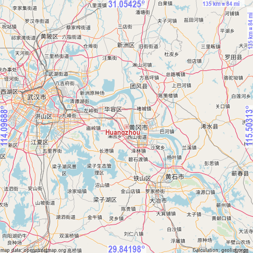
Huangzhou GPS coordinates[2]
30° 27' 0" North, 114° 48' 0" East
| Map corner | latitude | longitude |
|---|---|---|
| Upper-left | 31.05425°, | 114.09688° |
| Center: | 30.45°, | 114.8° |
| Lower-right: | 29.84198°, | 115.50313° |
| Map W x H: | 134.8×134.8 km | = 83.8×83.8mi |
| max Lat: | 53.31946° ⇑50% North |
| Huangzhou: | 30.45° |
| min Lat: | ⇓50% South 18.22056° |
| min Long | Huangzhou | max Long |
| 75.07348° | 114.8° | 134.28917° |
| W 53.1%⇐ | ⇒46.9% E |
Elevation
Elevation of Huangzhou is 19 m = 62 ft, and this is 465.8 m = 1528 ft below average elevation for this country.
| Max E: |
5622 m = 18445 ft | 83.4% |
| Avg. | 484.8 m = 1591 ft | |
| Huangzhou | 19 m = 62 ft | |
Min E: |
-3 m = -10 ft | 16.6% |
See also: Huangzhou elevation on elevation.city.
Geographical zone
Huangzhou is located in North temperate zone (between Tropic of Cancer and the Arctic Circle). Distance of this Northern Tropic circle is 779.8 km =484.5 mi to South.| Distance of | km | miles | from Huangzhou |
|---|---|---|---|
| North Pole | 6621.3 | 4114.3 | to North |
| Arctic Circle | 4015.5 | 2495.1 | to North |
| Tropic Cancer | 779.8 | 484.5 | to South |
| Equator | 3385.7 | 2103.8 | to South |


Nearby cities:
15 places around Huangzhou: (largest is in red/bold)
• Bahe
21.5 km =13.4 mi,  96°
96°
• Ducheng
14 km =8.7 mi,  41°
41°
• Ezhou
6.4 km =4 mi,  150°
150°
• E’zhou
10.2 km =6.3 mi,  125°
125°
• Fankou
4.9 km =3 mi,  139°
139°
• Gedian
19.9 km =12.4 mi,  297°
297°
• Huanggang
6.7 km =4.2 mi,  88°
88°
• Huarong
11.3 km =7 mi,  325°
325°
• Lukou
13.9 km =8.6 mi,  70°
70°
• Miaoling
17.7 km =11 mi,  269°
269°
• Shuangliu
21.9 km =13.6 mi,  316°
316°
• Taodian
18.7 km =11.6 mi,  57°
57°
• Xinmiao
13.9 km =8.6 mi,  119°
119°
• Yanji
20.8 km =12.9 mi,  105°
105°
• Zuoling
21.2 km =13.2 mi, 295°
Sources, notices
• [Note1] Compared only with cities in China existing in our database
• [Src1] Map data: © OpenStreetMap contributors (CC-BY-SA)
• [Src2] Other city data from geonames.org with taken over terms of usage.
• [Src3] Geographical zone / Annual Mean Temperature by Robert A. Rohde @ Wikipedia
