Zuoling geodata
Zuoling (Hubei) is a seat of a fourth-order administrative division; located in China in Asia/Shanghai (GMT+8) time zone. In our database, there are 1268 cities with bigger population. Compared to other cities in China, 50.6% of cities are located further ↓South; 52.1% of cities are located further ←West and 74.4% of cities have higher elevation than Zuoling. Note1


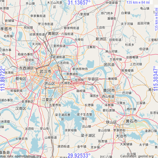
Zuoling GPS coordinates[2]
30° 31' 58.224" North, 114° 36' 1.224" East
| Map corner | latitude | longitude |
|---|---|---|
| Upper-left | 31.13657°, | 113.89722° |
| Center: | 30.53284°, | 114.60034° |
| Lower-right: | 29.92533°, | 115.30347° |
| Map W x H: | 134.7×134.7 km | = 83.7×83.7mi |
| max Lat: | 53.31946° ⇑49.4% North |
| Zuoling: | 30.53284° |
| min Lat: | ⇓50.6% South 18.22056° |
| min Long | Zuoling | max Long |
| 75.07348° | 114.60034° | 134.28917° |
| W 52.1%⇐ | ⇒47.9% E |
Elevation
Elevation of Zuoling is 38 m = 125 ft, and this is 446.8 m = 1466 ft below average elevation for this country.
| Max E: |
5622 m = 18445 ft | 74.4% |
| Avg. | 484.8 m = 1591 ft | |
| Zuoling | 38 m = 125 ft | |
Min E: |
-3 m = -10 ft | 25.6% |
See also: China elevation on elevation.city.
Geographical zone
Zuoling is located in North temperate zone (between Tropic of Cancer and the Arctic Circle). Distance of this Northern Tropic circle is 789 km =490.3 mi to South.| Distance of | km | miles | from Zuoling |
|---|---|---|---|
| North Pole | 6612.1 | 4108.6 | to North |
| Arctic Circle | 4006.2 | 2489.3 | to North |
| Tropic Cancer | 789 | 490.3 | to South |
| Equator | 3394.9 | 2109.5 | to South |


Nearby cities:
15 places around Zuoling: (largest is in red/bold)
• Baiyushan
13.4 km =8.3 mi,  306°
306°
• Dujiajing
19.9 km =12.4 mi,  316°
316°
• Gedian
1.6 km =1 mi,  88°
88°
• Guanshan
19.1 km =11.9 mi,  261°
261°
• Guanshang
14.5 km =9 mi,  341°
341°
• Heping
22.9 km =14.2 mi,  297°
297°
• Hongqi
18.1 km =11.2 mi, 296°
• Huangzhou
21.2 km =13.2 mi,  115°
115°
• Huarong
12.7 km =7.9 mi, 89°
• Huashan
8.3 km =5.2 mi,  277°
277°
• Liufang
17.5 km =10.9 mi,  236°
236°
• Miaoling
9.4 km =5.8 mi,  171°
171°
• Shuangliu
7.7 km =4.8 mi,  31°
31°
• Wangdian
12.1 km =7.5 mi, 257°
• Wudong
15 km =9.3 mi,  291°
291°
Sources, notices
• [Note1] Compared only with cities in China existing in our database
• [Src1] Map data: © OpenStreetMap contributors (CC-BY-SA)
• [Src2] Other city data from geonames.org with taken over terms of usage.
• [Src3] Geographical zone / Annual Mean Temperature by Robert A. Rohde @ Wikipedia
