Shuangliu geodata
Shuangliu (Hubei) is a seat of a fourth-order administrative division; located in China in Asia/Shanghai (GMT+8) time zone. In our database, there are 1268 cities with bigger population. Compared to other cities in China, 51.1% of cities are located further ↓South; 52.3% of cities are located further ←West and 79.8% of cities have higher elevation than Shuangliu. Note1


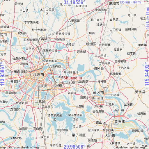
Shuangliu GPS coordinates[2]
30° 35' 31.92" North, 114° 38' 30.444" East
| Map corner | latitude | longitude |
|---|---|---|
| Upper-left | 31.19556°, | 113.93867° |
| Center: | 30.5922°, | 114.64179° |
| Lower-right: | 29.98506°, | 115.34492° |
| Map W x H: | 134.6×134.6 km | = 83.6×83.6mi |
| max Lat: | 53.31946° ⇑48.9% North |
| Shuangliu: | 30.5922° |
| min Lat: | ⇓51.1% South 18.22056° |
| min Long | Shuangliu | max Long |
| 75.07348° | 114.64179° | 134.28917° |
| W 52.3%⇐ | ⇒47.7% E |
Elevation
Elevation of Shuangliu is 27 m = 89 ft, and this is 457.8 m = 1502 ft below average elevation for this country.
| Max E: |
5622 m = 18445 ft | 79.8% |
| Avg. | 484.8 m = 1591 ft | |
| Shuangliu | 27 m = 89 ft | |
Min E: |
-3 m = -10 ft | 20.2% |
See also: China elevation on elevation.city.
Geographical zone
Shuangliu is located in North temperate zone (between Tropic of Cancer and the Arctic Circle). Distance of this Northern Tropic circle is 795.6 km =494.4 mi to South.| Distance of | km | miles | from Shuangliu |
|---|---|---|---|
| North Pole | 6605.5 | 4104.5 | to North |
| Arctic Circle | 3999.6 | 2485.2 | to North |
| Tropic Cancer | 795.6 | 494.4 | to South |
| Equator | 3401.5 | 2113.6 | to South |


Nearby cities:
15 places around Shuangliu: (largest is in red/bold)
• Baiyushan
14.8 km =9.2 mi,  275°
275°
• Dujiajing
19.4 km =12.1 mi,  293°
293°
• Gedian
7 km =4.3 mi,  200°
200°
• Guanshang
11.1 km =6.9 mi,  310°
310°
• Hongqi
20.2 km =12.6 mi,  274°
274°
• Huangzhou
21.9 km =13.6 mi,  136°
136°
• Huarong
10.9 km =6.8 mi,  126°
126°
• Huashan
13.4 km =8.3 mi,  245°
245°
• Miaoling
16.1 km =10 mi,  189°
189°
• Tianxing
23.4 km =14.5 mi, 291°
• Wangdian
18.3 km =11.4 mi,  239°
239°
• Wangji
21.5 km =13.4 mi,  15°
15°
• Wudong
18 km =11.2 mi, 266°
• Zhangduhu
16.8 km =10.4 mi,  57°
57°
• Zuoling
7.7 km =4.8 mi,  211°
211°
Sources, notices
• [Note1] Compared only with cities in China existing in our database
• [Src1] Map data: © OpenStreetMap contributors (CC-BY-SA)
• [Src2] Other city data from geonames.org with taken over terms of usage.
• [Src3] Geographical zone / Annual Mean Temperature by Robert A. Rohde @ Wikipedia
