Hougang geodata
Hougang (Jiangsu) is a seat of a fourth-order administrative division; located in China in Asia/Shanghai (GMT+8) time zone. In our database, there are 1268 cities with bigger population. Compared to other cities in China, 64.8% of cities are located further ↓South; 83.6% of cities are located further ←West and 98.9% of cities have higher elevation than Hougang. Note1


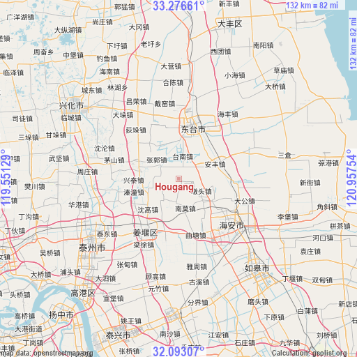
Hougang GPS coordinates[2]
32° 41' 12.48" North, 120° 15' 15.876" East
| Map corner | latitude | longitude |
|---|---|---|
| Upper-left | 33.27661°, | 119.55129° |
| Center: | 32.6868°, | 120.25441° |
| Lower-right: | 32.09307°, | 120.95754° |
| Map W x H: | 131.6×131.6 km | = 81.8×81.8mi |
| max Lat: | 53.31946° ⇑35.2% North |
| Hougang: | 32.6868° |
| min Lat: | ⇓64.8% South 18.22056° |
| min Long | Hougang | max Long |
| 75.07348° | 120.25441° | 134.28917° |
| W 83.6%⇐ | ⇒16.4% E |
Elevation
Elevation of Hougang is 3 m = 10 ft, and this is 481.8 m = 1581 ft below average elevation for this country.
| Max E: |
5622 m = 18445 ft | 98.9% |
| Avg. | 484.8 m = 1591 ft | |
| Hougang | 3 m = 10 ft | |
Min E: |
-3 m = -10 ft | 1.1% |
See also: China elevation on elevation.city.
Geographical zone
Hougang is located in North temperate zone (between Tropic of Cancer and the Arctic Circle). Distance of this Northern Tropic circle is 1028.5 km =639.1 mi to South.| Distance of | km | miles | from Hougang |
|---|---|---|---|
| North Pole | 6372.6 | 3959.7 | to North |
| Arctic Circle | 3766.7 | 2340.5 | to North |
| Tropic Cancer | 1028.5 | 639.1 | to South |
| Equator | 3634.4 | 2258.3 | to South |


Nearby cities:
15 places around Hougang: (largest is in red/bold)
• Anfeng
14.4 km =8.9 mi,  69°
69°
• Baidian
1.8 km =1.1 mi,  172°
172°
• Dainan
12.2 km =7.6 mi,  285°
285°
• Duntou
9.8 km =6.1 mi,  117°
117°
• Guangshan
13.8 km =8.6 mi,  342°
342°
• Liangduo
14.3 km =8.9 mi,  45°
45°
• Louzhuang
14.8 km =9.2 mi,  192°
192°
• Nanmo
10.4 km =6.5 mi, 168°
• Qintong
15.7 km =9.8 mi,  254°
254°
• Shengao
15.9 km =9.9 mi,  225°
225°
• Shiyan
7.8 km =4.8 mi,  300°
300°
• Tainan
8.5 km =5.3 mi,  9°
9°
• Xingtai
16.8 km =10.4 mi,  269°
269°
• Zhaowanzhuang
10.4 km =6.5 mi,  308°
308°
• Zhendong
10.3 km =6.4 mi, 246°
Sources, notices
• [Note1] Compared only with cities in China existing in our database
• [Src1] Map data: © OpenStreetMap contributors (CC-BY-SA)
• [Src2] Other city data from geonames.org with taken over terms of usage.
• [Src3] Geographical zone / Annual Mean Temperature by Robert A. Rohde @ Wikipedia
