Hechuan geodata
Hechuan (Chongqing) is a populated place; located in China in Asia/Shanghai (GMT+8) time zone. With population of 97,575 people, there are 436 cities with bigger population in this country. Compared to other cities in China, 54.1% of cities are located further ↑North; 86% of cities are located further →East and 56.6% of cities have lower elevation than Hechuan. Note1


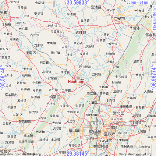
Hechuan GPS coordinates[2]
29° 59' 32.208" North, 106° 15' 52.596" East
| Map corner | latitude | longitude |
|---|---|---|
| Upper-left | 30.59938°, | 105.56149° |
| Center: | 29.99228°, | 106.26461° |
| Lower-right: | 29.38145°, | 106.96774° |
| Map W x H: | 135.4×135.4 km | = 84.1×84.1mi |
| max Lat: | 53.31946° ⇑54.1% North |
| Hechuan: | 29.99228° |
| min Lat: | ⇓45.9% South 18.22056° |
| min Long | Hechuan | max Long |
| 75.07348° | 106.26461° | 134.28917° |
| W 14%⇐ | ⇒86% E |
Elevation
Elevation of Hechuan is 222 m = 728 ft, and this is 262.8 m = 862 ft below average elevation for this country.
| Max E: |
5622 m = 18445 ft | 43.4% |
| Avg. | 484.8 m = 1591 ft | |
| Hechuan | 222 m = 728 ft | |
Min E: |
-3 m = -10 ft | 56.6% |
See also: Hechuan elevation on elevation.city.
Geographical zone
Hechuan is located in North temperate zone (between Tropic of Cancer and the Arctic Circle). Distance of this Northern Tropic circle is 728.9 km =452.9 mi to South.| Distance of | km | miles | from Hechuan |
|---|---|---|---|
| North Pole | 6672.2 | 4145.9 | to North |
| Arctic Circle | 4066.3 | 2526.7 | to North |
| Tropic Cancer | 728.9 | 452.9 | to South |
| Equator | 3334.8 | 2072.1 | to South |


Nearby cities:
15 places around Hechuan: (largest is in red/bold)
• Baiyang
17.9 km =11.1 mi,  258°
258°
• Batang
17.7 km =11 mi,  171°
171°
• Chengjiang
17.7 km =11 mi,  139°
139°
• Dashi
12 km =7.5 mi,  340°
340°
• Diaoyucheng
0.7 km =0.4 mi,  11°
11°
• Erping
14.7 km =9.1 mi,  225°
225°
• Jiuxian
15.7 km =9.8 mi,  202°
202°
• Nanjin
0.8 km =0.5 mi,  175°
175°
• Shuangfeng
16.3 km =10.1 mi,  77°
77°
• Shuikou
16.2 km =10.1 mi,  244°
244°
• Tongxi
13 km =8.1 mi,  274°
274°
• Weituo
12.5 km =7.8 mi,  295°
295°
• Yangcheng
1.2 km =0.7 mi,  314°
314°
• Yanjing
9.8 km =6.1 mi,  122°
122°
• Yunmen
11.6 km =7.2 mi,  29°
29°
Sources, notices
• [Note1] Compared only with cities in China existing in our database
• [Src1] Map data: © OpenStreetMap contributors (CC-BY-SA)
• [Src2] Other city data from geonames.org with taken over terms of usage.
• [Src3] Geographical zone / Annual Mean Temperature by Robert A. Rohde @ Wikipedia
