Yangcheng geodata
Yangcheng (Chongqing) is a seat of a fourth-order administrative division; located in China in Asia/Shanghai (GMT+8) time zone. In our database, there are 1268 cities with bigger population. Compared to other cities in China, 54% of cities are located further ↑North; 86% of cities are located further →East and 56.3% of cities have lower elevation than Yangcheng. Note1


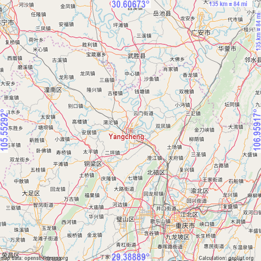
Yangcheng GPS coordinates[2]
29° 59' 58.848" North, 106° 15' 21.744" East
| Map corner | latitude | longitude |
|---|---|---|
| Upper-left | 30.60673°, | 105.55292° |
| Center: | 29.99968°, | 106.25604° |
| Lower-right: | 29.38889°, | 106.95917° |
| Map W x H: | 135.4×135.4 km | = 84.1×84.1mi |
| max Lat: | 53.31946° ⇑54% North |
| Yangcheng: | 29.99968° |
| min Lat: | ⇓46% South 18.22056° |
| min Long | Yangcheng | max Long |
| 75.07348° | 106.25604° | 134.28917° |
| W 14%⇐ | ⇒86% E |
Elevation
Elevation of Yangcheng is 219 m = 719 ft, and this is 265.8 m = 872 ft below average elevation for this country.
| Max E: |
5622 m = 18445 ft | 43.7% |
| Avg. | 484.8 m = 1591 ft | |
| Yangcheng | 219 m = 719 ft | |
Min E: |
-3 m = -10 ft | 56.3% |
See also: China elevation on elevation.city.
Geographical zone
Yangcheng is located in North temperate zone (between Tropic of Cancer and the Arctic Circle). Distance of this Northern Tropic circle is 729.7 km =453.4 mi to South.| Distance of | km | miles | from Yangcheng |
|---|---|---|---|
| North Pole | 6671.4 | 4145.4 | to North |
| Arctic Circle | 4065.5 | 2526.2 | to North |
| Tropic Cancer | 729.7 | 453.4 | to South |
| Equator | 3335.7 | 2072.7 | to South |


Nearby cities:
15 places around Yangcheng: (largest is in red/bold)
• Baiyang
17.3 km =10.7 mi,  255°
255°
• Batang
18.6 km =11.6 mi,  169°
169°
• Dashi
10.9 km =6.8 mi,  342°
342°
• Diaoyucheng
1 km =0.6 mi,  95°
95°
• Erping
14.7 km =9.1 mi,  220°
220°
• Guandu
18.9 km =11.7 mi,  61°
61°
• Hechuan
1.2 km =0.7 mi,  134°
134°
• Jiuxian
16.1 km =10 mi,  198°
198°
• Nanjin
1.9 km =1.2 mi,  151°
151°
• Shuangfeng
16.9 km =10.5 mi,  81°
81°
• Shuikou
15.8 km =9.8 mi,  240°
240°
• Tongxi
12.1 km =7.5 mi,  270°
270°
• Weituo
11.4 km =7.1 mi,  293°
293°
• Yanjing
10.9 km =6.8 mi,  123°
123°
• Yunmen
11.3 km =7 mi,  35°
35°
Sources, notices
• [Note1] Compared only with cities in China existing in our database
• [Src1] Map data: © OpenStreetMap contributors (CC-BY-SA)
• [Src2] Other city data from geonames.org with taken over terms of usage.
• [Src3] Geographical zone / Annual Mean Temperature by Robert A. Rohde @ Wikipedia
