Hexi geodata
Hexi (Zhejiang) is a seat of a fourth-order administrative division; located in China in Asia/Shanghai (GMT+8) time zone. In our database, there are 1268 cities with bigger population. Compared to other cities in China, 74.3% of cities are located further ↑North; 79.6% of cities are located further ←West and 54.6% of cities have lower elevation than Hexi. Note1


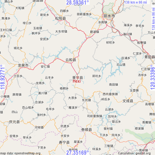
Hexi GPS coordinates[2]
27° 58' 27.984" North, 119° 37' 50.988" East
| Map corner | latitude | longitude |
|---|---|---|
| Upper-left | 28.59361°, | 118.92771° |
| Center: | 27.97444°, | 119.63083° |
| Lower-right: | 27.35169°, | 120.33396° |
| Map W x H: | 138.1×138.1 km | = 85.8×85.8mi |
| max Lat: | 53.31946° ⇑74.3% North |
| Hexi: | 27.97444° |
| min Lat: | ⇓25.7% South 18.22056° |
| min Long | Hexi | max Long |
| 75.07348° | 119.63083° | 134.28917° |
| W 79.6%⇐ | ⇒20.4% E |
Elevation
Elevation of Hexi is 203 m = 666 ft, and this is 281.8 m = 925 ft below average elevation for this country.
| Max E: |
5622 m = 18445 ft | 45.4% |
| Avg. | 484.8 m = 1591 ft | |
| Hexi | 203 m = 666 ft | |
Min E: |
-3 m = -10 ft | 54.6% |
See also: China elevation on elevation.city.
Geographical zone
Hexi is located in North temperate zone (between Tropic of Cancer and the Arctic Circle). Distance of this Northern Tropic circle is 504.5 km =313.5 mi to South.| Distance of | km | miles | from Hexi |
|---|---|---|---|
| North Pole | 6896.6 | 4285.3 | to North |
| Arctic Circle | 4290.7 | 2666.1 | to North |
| Tropic Cancer | 504.5 | 313.5 | to South |
| Equator | 3110.5 | 1932.8 | to South |


Nearby cities:
15 places around Hexi: (largest is in red/bold)
• Biaoxi
18.9 km =11.7 mi,  223°
223°
• Chengzhao
5.7 km =3.5 mi,  192°
192°
• Daji
18.4 km =11.4 mi, 193°
• Dajun
7.1 km =4.4 mi,  251°
251°
• Dongkeng
21.3 km =13.2 mi,  158°
158°
• Huangliao
25.3 km =15.7 mi,  97°
97°
• Jingnan
23.7 km =14.7 mi,  176°
176°
• Luci
24.9 km =15.5 mi,  244°
244°
• Meiqi
14.5 km =9 mi,  118°
118°
• Shawan
21.1 km =13.1 mi,  230°
230°
• Shiyang
26.3 km =16.3 mi, 120°
• Wutong
15.2 km =9.4 mi, 231°
• Xiayang
20.2 km =12.6 mi, 122°
• Yunfeng
25.1 km =15.6 mi,  270°
270°
• Zhengkeng
17.1 km =10.6 mi,  84°
84°
Sources, notices
• [Note1] Compared only with cities in China existing in our database
• [Src1] Map data: © OpenStreetMap contributors (CC-BY-SA)
• [Src2] Other city data from geonames.org with taken over terms of usage.
• [Src3] Geographical zone / Annual Mean Temperature by Robert A. Rohde @ Wikipedia
