Chengzhao geodata
Chengzhao (Zhejiang) is a seat of a fourth-order administrative division; located in China in Asia/Shanghai (GMT+8) time zone. In our database, there are 1268 cities with bigger population. Compared to other cities in China, 74.5% of cities are located further ↑North; 79.6% of cities are located further ←West and 71.6% of cities have lower elevation than Chengzhao. Note1


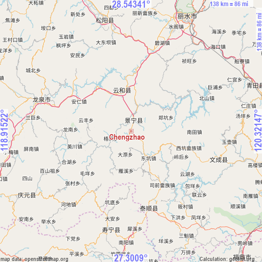
Chengzhao GPS coordinates[2]
27° 55' 26.184" North, 119° 37' 6.024" East
| Map corner | latitude | longitude |
|---|---|---|
| Upper-left | 28.54341°, | 118.91522° |
| Center: | 27.92394°, | 119.61834° |
| Lower-right: | 27.3009°, | 120.32147° |
| Map W x H: | 138.2×138.2 km | = 85.9×85.9mi |
| max Lat: | 53.31946° ⇑74.5% North |
| Chengzhao: | 27.92394° |
| min Lat: | ⇓25.5% South 18.22056° |
| min Long | Chengzhao | max Long |
| 75.07348° | 119.61834° | 134.28917° |
| W 79.6%⇐ | ⇒20.4% E |
Elevation
Elevation of Chengzhao is 442 m = 1450 ft, and this is 42.8 m = 140 ft below average elevation for this country.
| Max E: |
5622 m = 18445 ft | 28.4% |
| Avg. | 484.8 m = 1591 ft | |
| Chengzhao | 442 m = 1450 ft | |
Min E: |
-3 m = -10 ft | 71.6% |
See also: China elevation on elevation.city.
Geographical zone
Chengzhao is located in North temperate zone (between Tropic of Cancer and the Arctic Circle). Distance of this Northern Tropic circle is 498.9 km =310 mi to South.| Distance of | km | miles | from Chengzhao |
|---|---|---|---|
| North Pole | 6902.2 | 4288.8 | to North |
| Arctic Circle | 4296.3 | 2669.6 | to North |
| Tropic Cancer | 498.9 | 310 | to South |
| Equator | 3104.9 | 1929.3 | to South |


Nearby cities:
15 places around Chengzhao: (largest is in red/bold)
• Biaoxi
14.3 km =8.9 mi,  235°
235°
• Dadi
23.5 km =14.6 mi,  221°
221°
• Daji
12.6 km =7.8 mi,  194°
194°
• Dajun
6.5 km =4 mi,  301°
301°
• Dongkeng
16.9 km =10.5 mi,  147°
147°
• Hexi
5.7 km =3.5 mi,  12°
12°
• Huangqiao
23.8 km =14.8 mi,  132°
132°
• Jingnan
18.3 km =11.4 mi,  171°
171°
• Luci
21.8 km =13.5 mi,  256°
256°
• Meiqi
14 km =8.7 mi,  95°
95°
• Shawan
17 km =10.6 mi, 242°
• Wutong
11.3 km =7 mi,  250°
250°
• Xiayang
19 km =11.8 mi,  105°
105°
• Yanxi
21.1 km =13.1 mi, 186°
• Zhengkeng
19.6 km =12.2 mi,  68°
68°
Sources, notices
• [Note1] Compared only with cities in China existing in our database
• [Src1] Map data: © OpenStreetMap contributors (CC-BY-SA)
• [Src2] Other city data from geonames.org with taken over terms of usage.
• [Src3] Geographical zone / Annual Mean Temperature by Robert A. Rohde @ Wikipedia
