Cangshuipu geodata
Cangshuipu (Hunan) is a seat of a fourth-order administrative division; located in China in Asia/Shanghai (GMT+8) time zone. In our database, there are 1268 cities with bigger population. Compared to other cities in China, 70.2% of cities are located further ↑North; 60.4% of cities are located further →East and 70.3% of cities have higher elevation than Cangshuipu. Note1


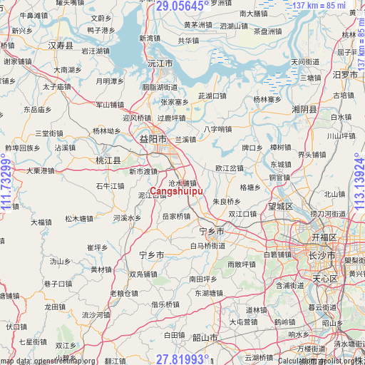
Cangshuipu GPS coordinates[2]
28° 26' 24" North, 112° 26' 9.996" East
| Map corner | latitude | longitude |
|---|---|---|
| Upper-left | 29.05645°, | 111.73299° |
| Center: | 28.44°, | 112.43611° |
| Lower-right: | 27.81993°, | 113.13924° |
| Map W x H: | 137.5×137.5 km | = 85.4×85.4mi |
| max Lat: | 53.31946° ⇑70.2% North |
| Cangshuipu: | 28.44° |
| min Lat: | ⇓29.8% South 18.22056° |
| min Long | Cangshuipu | max Long |
| 75.07348° | 112.43611° | 134.28917° |
| W 39.6%⇐ | ⇒60.4% E |
Elevation
Elevation of Cangshuipu is 51 m = 167 ft, and this is 433.8 m = 1423 ft below average elevation for this country.
| Max E: |
5622 m = 18445 ft | 70.3% |
| Avg. | 484.8 m = 1591 ft | |
| Cangshuipu | 51 m = 167 ft | |
Min E: |
-3 m = -10 ft | 29.7% |
See also: China elevation on elevation.city.
Geographical zone
Cangshuipu is located in North temperate zone (between Tropic of Cancer and the Arctic Circle). Distance of this Northern Tropic circle is 556.3 km =345.7 mi to South.| Distance of | km | miles | from Cangshuipu |
|---|---|---|---|
| North Pole | 6844.8 | 4253.2 | to North |
| Arctic Circle | 4238.9 | 2633.9 | to North |
| Tropic Cancer | 556.3 | 345.7 | to South |
| Equator | 3162.2 | 1964.9 | to South |


Nearby cities:
15 places around Cangshuipu: (largest is in red/bold)
• Bazishao
23.7 km =14.7 mi,  32°
32°
• Damatou
22 km =13.7 mi,  333°
333°
• Heshan
17.9 km =11.1 mi, 332°
• Huishangang
25.6 km =15.9 mi,  229°
229°
• Oujiangcha
15.9 km =9.9 mi,  78°
78°
• Qiaokou
29.9 km =18.6 mi, 76°
• Shiniujiang
27.1 km =16.8 mi,  268°
268°
• Taohuajiang
31.8 km =19.8 mi,  287°
287°
• Xinqiaohe
30.8 km =19.1 mi,  307°
307°
• Xinshidu
16.2 km =10.1 mi, 289°
• Yingfengqiao
29.8 km =18.5 mi, 325°
• Yiyang
19.6 km =12.2 mi, 327°
• Yuejiaqiao
12.3 km =7.6 mi,  179°
179°
• Yujia’ao
32.2 km =20 mi,  211°
211°
• Yutan
23.6 km =14.7 mi,  148°
148°
Sources, notices
• [Note1] Compared only with cities in China existing in our database
• [Src1] Map data: © OpenStreetMap contributors (CC-BY-SA)
• [Src2] Other city data from geonames.org with taken over terms of usage.
• [Src3] Geographical zone / Annual Mean Temperature by Robert A. Rohde @ Wikipedia
