Hengfan geodata
Hengfan (Zhejiang) is a seat of a fourth-order administrative division; located in China in Asia/Shanghai (GMT+8) time zone. In our database, there are 1268 cities with bigger population. Compared to other cities in China, 50.9% of cities are located further ↑North; 80.2% of cities are located further ←West and 71.6% of cities have higher elevation than Hengfan. Note1


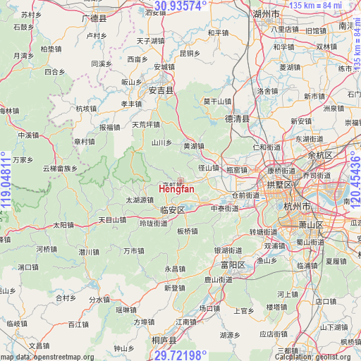
Hengfan GPS coordinates[2]
30° 19' 50.664" North, 119° 45' 4.428" East
| Map corner | latitude | longitude |
|---|---|---|
| Upper-left | 30.93574°, | 119.04811° |
| Center: | 30.33074°, | 119.75123° |
| Lower-right: | 29.72198°, | 120.45436° |
| Map W x H: | 135×135 km | = 83.9×83.9mi |
| max Lat: | 53.31946° ⇑50.9% North |
| Hengfan: | 30.33074° |
| min Lat: | ⇓49.1% South 18.22056° |
| min Long | Hengfan | max Long |
| 75.07348° | 119.75123° | 134.28917° |
| W 80.2%⇐ | ⇒19.8% E |
Elevation
Elevation of Hengfan is 46 m = 151 ft, and this is 438.8 m = 1440 ft below average elevation for this country.
| Max E: |
5622 m = 18445 ft | 71.6% |
| Avg. | 484.8 m = 1591 ft | |
| Hengfan | 46 m = 151 ft | |
Min E: |
-3 m = -10 ft | 28.4% |
See also: China elevation on elevation.city.
Geographical zone
Hengfan is located in North temperate zone (between Tropic of Cancer and the Arctic Circle). Distance of this Northern Tropic circle is 766.5 km =476.3 mi to South.| Distance of | km | miles | from Hengfan |
|---|---|---|---|
| North Pole | 6634.6 | 4122.5 | to North |
| Arctic Circle | 4028.7 | 2503.3 | to North |
| Tropic Cancer | 766.5 | 476.3 | to South |
| Equator | 3372.5 | 2095.6 | to South |


Nearby cities:
15 places around Hengfan: (largest is in red/bold)
• Baizhang
22.1 km =13.7 mi,  353°
353°
• Banqiao
18.5 km =11.5 mi,  171°
171°
• Cangqian
23.4 km =14.5 mi,  100°
100°
• Gaohong
3.1 km =1.9 mi,  247°
247°
• Huanghu
14.3 km =8.9 mi,  21°
21°
• Linglong
19.1 km =11.9 mi,  214°
214°
• Lin’an
11 km =6.8 mi,  196°
196°
• Luniao
13.7 km =8.5 mi,  1°
1°
• Panbanqiao
13 km =8.1 mi,  62°
62°
• Pingyao
21.8 km =13.5 mi,  69°
69°
• Qingshanhu
10.7 km =6.6 mi,  146°
146°
• Shanggan
17.9 km =11.1 mi,  192°
192°
• Shuangxi
11 km =6.8 mi,  40°
40°
• Yuhang
18.5 km =11.5 mi,  109°
109°
• Zhongtai
19.6 km =12.2 mi,  120°
120°
Sources, notices
• [Note1] Compared only with cities in China existing in our database
• [Src1] Map data: © OpenStreetMap contributors (CC-BY-SA)
• [Src2] Other city data from geonames.org with taken over terms of usage.
• [Src3] Geographical zone / Annual Mean Temperature by Robert A. Rohde @ Wikipedia
