Lin’an geodata
Lin’an (Zhejiang) is a seat of a third-order administrative division; located in China in Asia/Shanghai (GMT+8) time zone. In our database, there are 1268 cities with bigger population. Compared to other cities in China, 51.8% of cities are located further ↑North; 80.1% of cities are located further ←West and 70.3% of cities have higher elevation than Lin’an. Note1


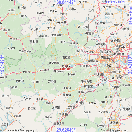
Lin’an GPS coordinates[2]
30° 14' 8.988" North, 119° 43' 5.016" East
| Map corner | latitude | longitude |
|---|---|---|
| Upper-left | 30.84142°, | 119.01494° |
| Center: | 30.23583°, | 119.71806° |
| Lower-right: | 29.62649°, | 120.42119° |
| Map W x H: | 135.1×135.1 km | = 83.9×83.9mi |
| max Lat: | 53.31946° ⇑51.8% North |
| Lin’an: | 30.23583° |
| min Lat: | ⇓48.2% South 18.22056° |
| min Long | Lin’an | max Long |
| 75.07348° | 119.71806° | 134.28917° |
| W 80.1%⇐ | ⇒19.9% E |
Elevation
Elevation of Lin’an is 51 m = 167 ft, and this is 433.8 m = 1423 ft below average elevation for this country.
| Max E: |
5622 m = 18445 ft | 70.3% |
| Avg. | 484.8 m = 1591 ft | |
| Lin’an | 51 m = 167 ft | |
Min E: |
-3 m = -10 ft | 29.7% |
See also: China elevation on elevation.city.
Geographical zone
Lin’an is located in North temperate zone (between Tropic of Cancer and the Arctic Circle). Distance of this Northern Tropic circle is 756 km =469.8 mi to South.| Distance of | km | miles | from Lin’an |
|---|---|---|---|
| North Pole | 6645.2 | 4129.1 | to North |
| Arctic Circle | 4039.3 | 2509.9 | to North |
| Tropic Cancer | 756 | 469.8 | to South |
| Equator | 3361.9 | 2089 | to South |


Nearby cities:
15 places around Lin’an: (largest is in red/bold)
• Banqiao
9.8 km =6.1 mi,  141°
141°
• Chunjian
20.6 km =12.8 mi,  149°
149°
• Dongqiao
22 km =13.7 mi,  216°
216°
• Gaohong
9.4 km =5.8 mi,  1°
1°
• Hengfan
11 km =6.8 mi,  16°
16°
• Linglong
9.2 km =5.7 mi,  236°
236°
• Panbanqiao
22.2 km =13.8 mi,  41°
41°
• Qingshanhu
9.2 km =5.7 mi,  79°
79°
• Sankou
15.4 km =9.6 mi,  171°
171°
• Shanggan
7 km =4.3 mi,  185°
185°
• Shuangxi
21.5 km =13.4 mi,  28°
28°
• Wanshi
21 km =13 mi, 223°
• Yongchang
22 km =13.7 mi,  176°
176°
• Yuhang
21.1 km =13.1 mi, 77°
• Zhongtai
20.1 km =12.5 mi,  88°
88°
Sources, notices
• [Note1] Compared only with cities in China existing in our database
• [Src1] Map data: © OpenStreetMap contributors (CC-BY-SA)
• [Src2] Other city data from geonames.org with taken over terms of usage.
• [Src3] Geographical zone / Annual Mean Temperature by Robert A. Rohde @ Wikipedia
