Zhongtai geodata
Zhongtai (Zhejiang) is a seat of a fourth-order administrative division; located in China in Asia/Shanghai (GMT+8) time zone. In our database, there are 1268 cities with bigger population. Compared to other cities in China, 51.7% of cities are located further ↑North; 81.4% of cities are located further ←West and 88.7% of cities have higher elevation than Zhongtai. Note1


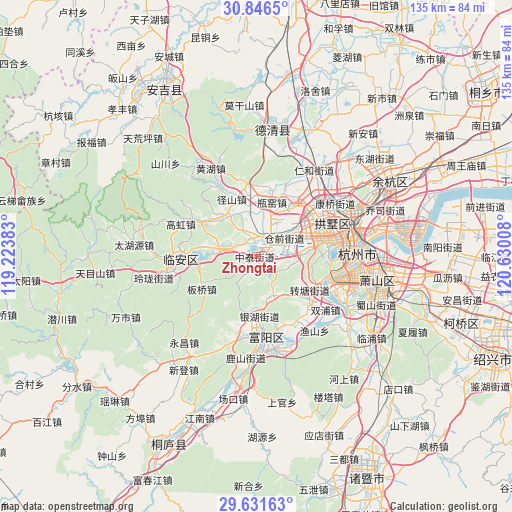
Zhongtai GPS coordinates[2]
30° 14' 27.384" North, 119° 55' 37.02" East
| Map corner | latitude | longitude |
|---|---|---|
| Upper-left | 30.8465°, | 119.22383° |
| Center: | 30.24094°, | 119.92695° |
| Lower-right: | 29.63163°, | 120.63008° |
| Map W x H: | 135.1×135.1 km | = 83.9×83.9mi |
| max Lat: | 53.31946° ⇑51.7% North |
| Zhongtai: | 30.24094° |
| min Lat: | ⇓48.3% South 18.22056° |
| min Long | Zhongtai | max Long |
| 75.07348° | 119.92695° | 134.28917° |
| W 81.4%⇐ | ⇒18.6% E |
Elevation
Elevation of Zhongtai is 11 m = 36 ft, and this is 473.8 m = 1554 ft below average elevation for this country.
| Max E: |
5622 m = 18445 ft | 88.7% |
| Avg. | 484.8 m = 1591 ft | |
| Zhongtai | 11 m = 36 ft | |
Min E: |
-3 m = -10 ft | 11.3% |
See also: China elevation on elevation.city.
Geographical zone
Zhongtai is located in North temperate zone (between Tropic of Cancer and the Arctic Circle). Distance of this Northern Tropic circle is 756.6 km =470.1 mi to South.| Distance of | km | miles | from Zhongtai |
|---|---|---|---|
| North Pole | 6644.6 | 4128.8 | to North |
| Arctic Circle | 4038.7 | 2509.5 | to North |
| Tropic Cancer | 756.6 | 470.1 | to South |
| Equator | 3362.5 | 2089.4 | to South |


Nearby cities:
15 places around Zhongtai: (largest is in red/bold)
• Banqiao
16.3 km =10.1 mi,  239°
239°
• Cangqian
8.3 km =5.2 mi,  47°
47°
• Gaoqiao
15.5 km =9.6 mi,  176°
176°
• Gudang
18.9 km =11.7 mi,  77°
77°
• Jiangcun
14.1 km =8.8 mi,  69°
69°
• Liuxia
12.1 km =7.5 mi,  87°
87°
• Panbanqiao
16.9 km =10.5 mi,  341°
341°
• Pingyao
18.1 km =11.2 mi,  11°
11°
• Qingshanhu
11.1 km =6.9 mi,  275°
275°
• Sandun
17.2 km =10.7 mi,  57°
57°
• Shoujiang
13.1 km =8.1 mi,  166°
166°
• Xianlin
5.5 km =3.4 mi,  107°
107°
• Xihu
18.4 km =11.4 mi, 89°
• Yuhang
3.9 km =2.4 mi, 7°
• Zhuantang
16.7 km =10.4 mi,  120°
120°
Sources, notices
• [Note1] Compared only with cities in China existing in our database
• [Src1] Map data: © OpenStreetMap contributors (CC-BY-SA)
• [Src2] Other city data from geonames.org with taken over terms of usage.
• [Src3] Geographical zone / Annual Mean Temperature by Robert A. Rohde @ Wikipedia
