Linglong geodata
Linglong (Zhejiang) is a seat of a fourth-order administrative division; located in China in Asia/Shanghai (GMT+8) time zone. In our database, there are 1268 cities with bigger population. Compared to other cities in China, 52.2% of cities are located further ↑North; 79.6% of cities are located further ←West and 65.2% of cities have higher elevation than Linglong. Note1


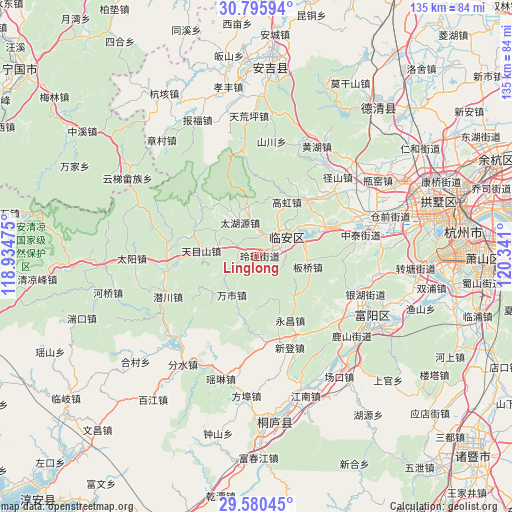
Linglong GPS coordinates[2]
30° 11' 24.252" North, 119° 38' 16.332" East
| Map corner | latitude | longitude |
|---|---|---|
| Upper-left | 30.79594°, | 118.93475° |
| Center: | 30.19007°, | 119.63787° |
| Lower-right: | 29.58045°, | 120.341° |
| Map W x H: | 135.1×135.2 km | = 83.9×84mi |
| max Lat: | 53.31946° ⇑52.2% North |
| Linglong: | 30.19007° |
| min Lat: | ⇓47.8% South 18.22056° |
| min Long | Linglong | max Long |
| 75.07348° | 119.63787° | 134.28917° |
| W 79.6%⇐ | ⇒20.4% E |
Elevation
Elevation of Linglong is 72 m = 236 ft, and this is 412.8 m = 1354 ft below average elevation for this country.
| Max E: |
5622 m = 18445 ft | 65.2% |
| Avg. | 484.8 m = 1591 ft | |
| Linglong | 72 m = 236 ft | |
Min E: |
-3 m = -10 ft | 34.8% |
See also: China elevation on elevation.city.
Geographical zone
Linglong is located in North temperate zone (between Tropic of Cancer and the Arctic Circle). Distance of this Northern Tropic circle is 750.9 km =466.6 mi to South.| Distance of | km | miles | from Linglong |
|---|---|---|---|
| North Pole | 6650.2 | 4132.2 | to North |
| Arctic Circle | 4044.4 | 2513.1 | to North |
| Tropic Cancer | 750.9 | 466.6 | to South |
| Equator | 3356.8 | 2085.8 | to South |


Nearby cities:
15 places around Linglong: (largest is in red/bold)
• Banqiao
14 km =8.7 mi,  100°
100°
• Chunjian
22.1 km =13.7 mi,  124°
124°
• Dongqiao
13.7 km =8.5 mi,  202°
202°
• Gaohong
16.6 km =10.3 mi,  28°
28°
• Hengfan
19.1 km =11.9 mi, 34°
• Lin’an
9.2 km =5.7 mi,  56°
56°
• Qingshanhu
18 km =11.2 mi,  68°
68°
• Sankou
14.3 km =8.9 mi,  135°
135°
• Shanggan
7.3 km =4.5 mi, 104°
• Wanshi
12.2 km =7.6 mi,  212°
212°
• Xitianmu
18 km =11.2 mi,  297°
297°
• Xukou
23.1 km =14.4 mi,  173°
173°
• Yongchang
19.2 km =11.9 mi,  151°
151°
• Yuqian
23.5 km =14.6 mi,  269°
269°
• Zaoxi
14.2 km =8.8 mi, 274°
Sources, notices
• [Note1] Compared only with cities in China existing in our database
• [Src1] Map data: © OpenStreetMap contributors (CC-BY-SA)
• [Src2] Other city data from geonames.org with taken over terms of usage.
• [Src3] Geographical zone / Annual Mean Temperature by Robert A. Rohde @ Wikipedia
