Hejia geodata
Hejia (Zhejiang) is a seat of a fourth-order administrative division; located in China in Asia/Shanghai (GMT+8) time zone. In our database, there are 1268 cities with bigger population. Compared to other cities in China, 61.6% of cities are located further ↑North; 72.1% of cities are located further ←West and 57.9% of cities have lower elevation than Hejia. Note1


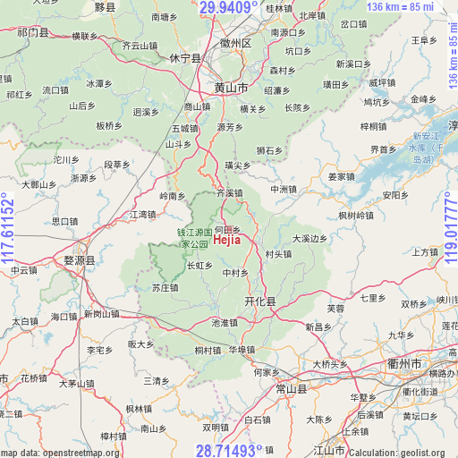
Hejia GPS coordinates[2]
29° 19' 47.136" North, 118° 18' 52.704" East
| Map corner | latitude | longitude |
|---|---|---|
| Upper-left | 29.9409°, | 117.61152° |
| Center: | 29.32976°, | 118.31464° |
| Lower-right: | 28.71493°, | 119.01777° |
| Map W x H: | 136.3×136.3 km | = 84.7×84.7mi |
| max Lat: | 53.31946° ⇑61.6% North |
| Hejia: | 29.32976° |
| min Lat: | ⇓38.4% South 18.22056° |
| min Long | Hejia | max Long |
| 75.07348° | 118.31464° | 134.28917° |
| W 72.1%⇐ | ⇒27.9% E |
Elevation
Elevation of Hejia is 235 m = 771 ft, and this is 249.8 m = 820 ft below average elevation for this country.
| Max E: |
5622 m = 18445 ft | 42.1% |
| Avg. | 484.8 m = 1591 ft | |
| Hejia | 235 m = 771 ft | |
Min E: |
-3 m = -10 ft | 57.9% |
See also: China elevation on elevation.city.
Geographical zone
Hejia is located in North temperate zone (between Tropic of Cancer and the Arctic Circle). Distance of this Northern Tropic circle is 655.2 km =407.1 mi to South.| Distance of | km | miles | from Hejia |
|---|---|---|---|
| North Pole | 6745.9 | 4191.7 | to North |
| Arctic Circle | 4140 | 2572.5 | to North |
| Tropic Cancer | 655.2 | 407.1 | to South |
| Equator | 3261.2 | 2026.4 | to South |


Nearby cities:
15 places around Hejia: (largest is in red/bold)
• Cuntou
16.5 km =10.3 mi,  115°
115°
• Dongshan
22.4 km =13.9 mi,  97°
97°
• Fangcun
12.2 km =7.6 mi,  217°
217°
• Jincun
22.5 km =14 mi,  137°
137°
• Kaihua Chengguanzhen
22.4 km =13.9 mi,  155°
155°
• Majin
9.9 km =6.2 mi,  107°
107°
• Shandi
15.3 km =9.5 mi,  128°
128°
• Shichuan
19 km =11.8 mi,  310°
310°
• Tangwu
16.2 km =10.1 mi,  83°
83°
• Wenshan
22.4 km =13.9 mi,  171°
171°
• Xiashan
8.9 km =5.5 mi,  88°
88°
• Yinkeng
16.7 km =10.4 mi,  150°
150°
• Yujia
21.3 km =13.2 mi,  45°
45°
• Zhangcun
12.5 km =7.8 mi, 170°
• Zhongzhou
20.6 km =12.8 mi, 52°
Sources, notices
• [Note1] Compared only with cities in China existing in our database
• [Src1] Map data: © OpenStreetMap contributors (CC-BY-SA)
• [Src2] Other city data from geonames.org with taken over terms of usage.
• [Src3] Geographical zone / Annual Mean Temperature by Robert A. Rohde @ Wikipedia
