Dongshan geodata
Dongshan (Zhejiang) is a seat of a fourth-order administrative division; located in China in Asia/Shanghai (GMT+8) time zone. In our database, there are 1268 cities with bigger population. Compared to other cities in China, 61.9% of cities are located further ↑North; 73.5% of cities are located further ←West and 56.3% of cities have lower elevation than Dongshan. Note1


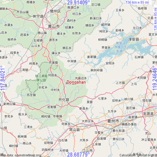
Dongshan GPS coordinates[2]
29° 18' 10.008" North, 118° 32' 35.988" East
| Map corner | latitude | longitude |
|---|---|---|
| Upper-left | 29.91409°, | 117.84021° |
| Center: | 29.30278°, | 118.54333° |
| Lower-right: | 28.68779°, | 119.24646° |
| Map W x H: | 136.4×136.4 km | = 84.8×84.8mi |
| max Lat: | 53.31946° ⇑61.9% North |
| Dongshan: | 29.30278° |
| min Lat: | ⇓38.1% South 18.22056° |
| min Long | Dongshan | max Long |
| 75.07348° | 118.54333° | 134.28917° |
| W 73.5%⇐ | ⇒26.5% E |
Elevation
Elevation of Dongshan is 219 m = 719 ft, and this is 265.8 m = 872 ft below average elevation for this country.
| Max E: |
5622 m = 18445 ft | 43.7% |
| Avg. | 484.8 m = 1591 ft | |
| Dongshan | 219 m = 719 ft | |
Min E: |
-3 m = -10 ft | 56.3% |
See also: China elevation on elevation.city.
Geographical zone
Dongshan is located in North temperate zone (between Tropic of Cancer and the Arctic Circle). Distance of this Northern Tropic circle is 652.2 km =405.3 mi to South.| Distance of | km | miles | from Dongshan |
|---|---|---|---|
| North Pole | 6748.9 | 4193.6 | to North |
| Arctic Circle | 4143 | 2574.3 | to North |
| Tropic Cancer | 652.2 | 405.3 | to South |
| Equator | 3258.2 | 2024.6 | to South |


Nearby cities:
15 places around Dongshan: (largest is in red/bold)
• Baima
18 km =11.2 mi,  111°
111°
• Cuntou
8.4 km =5.2 mi,  240°
240°
• Dongwu
7.6 km =4.7 mi,  176°
176°
• Fengshuling
17.2 km =10.7 mi,  65°
65°
• Huanggu
2.9 km =1.8 mi,  145°
145°
• Jincun
15.1 km =9.4 mi,  207°
207°
• Longyuan
11.8 km =7.3 mi,  20°
20°
• Majin
12.7 km =7.9 mi,  270°
270°
• Shandi
12.2 km =7.6 mi, 237°
• Tangwu
7.8 km =4.8 mi,  308°
308°
• Xiashan
13.7 km =8.5 mi,  283°
283°
• Xikou
18 km =11.2 mi,  194°
194°
• Yangqitan
14.7 km =9.1 mi,  0°
0°
• Yinkeng
18.2 km =11.3 mi,  230°
230°
• Zhongzhou
16.5 km =10.3 mi,  339°
339°
Sources, notices
• [Note1] Compared only with cities in China existing in our database
• [Src1] Map data: © OpenStreetMap contributors (CC-BY-SA)
• [Src2] Other city data from geonames.org with taken over terms of usage.
• [Src3] Geographical zone / Annual Mean Temperature by Robert A. Rohde @ Wikipedia
