Hede geodata
Hede (Jiangsu) is a seat of a third-order administrative division; located in China in Asia/Shanghai (GMT+8) time zone. With population of 89,107 people, there are 480 cities with bigger population in this country. Compared to other cities in China, 69.1% of cities are located further ↓South; 83.6% of cities are located further ←West and 99.4% of cities have higher elevation than Hede. Note1


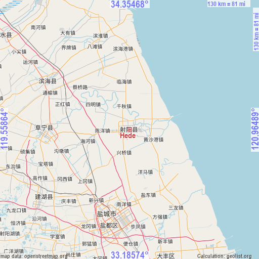
Hede GPS coordinates[2]
33° 46' 19.92" North, 120° 15' 42.336" East
| Map corner | latitude | longitude |
|---|---|---|
| Upper-left | 34.35468°, | 119.55864° |
| Center: | 33.7722°, | 120.26176° |
| Lower-right: | 33.18574°, | 120.96489° |
| Map W x H: | 130×130 km | = 80.8×80.8mi |
| max Lat: | 53.31946° ⇑30.9% North |
| Hede: | 33.7722° |
| min Lat: | ⇓69.1% South 18.22056° |
| min Long | Hede | max Long |
| 75.07348° | 120.26176° | 134.28917° |
| W 83.6%⇐ | ⇒16.4% E |
Elevation
Elevation of Hede is 2 m = 7 ft, and this is 482.8 m = 1584 ft below average elevation for this country.
| Max E: |
5622 m = 18445 ft | 99.4% |
| Avg. | 484.8 m = 1591 ft | |
| Hede | 2 m = 7 ft | |
Min E: |
-3 m = -10 ft | 0.6% |
See also: Hede elevation on elevation.city.
Geographical zone
Hede is located in North temperate zone (between Tropic of Cancer and the Arctic Circle). Distance of this Northern Tropic circle is 1149.2 km =714.1 mi to South.| Distance of | km | miles | from Hede |
|---|---|---|---|
| North Pole | 6251.9 | 3884.7 | to North |
| Arctic Circle | 3646.1 | 2265.6 | to North |
| Tropic Cancer | 1149.2 | 714.1 | to South |
| Equator | 3755.1 | 2333.3 | to South |


Nearby cities:
15 places around Hede: (largest is in red/bold)
• Baju
46.1 km =28.6 mi,  326°
326°
• Batan
44.9 km =27.9 mi,  336°
336°
• Dayou
61 km =37.9 mi,  324°
324°
• Dongkan
47.1 km =29.3 mi,  302°
302°
• Fangqiang
46.2 km =28.7 mi,  160°
160°
• Liutao
57.4 km =35.7 mi,  311°
311°
• Qitao
58 km =36 mi, 319°
• Sanlong
45.6 km =28.3 mi,  149°
149°
• Xindu
49.3 km =30.6 mi,  192°
192°
• Xinfeng
58.8 km =36.5 mi, 162°
• Yancheng
47.1 km =29.3 mi, 191°
• Yulong
44.9 km =27.9 mi,  195°
195°
• Yunhe
61 km =37.9 mi, 304°
• Zhangji
64.3 km =40 mi, 298°
• Zhendong
40.4 km =25.1 mi,  354°
354°
Sources, notices
• [Note1] Compared only with cities in China existing in our database
• [Src1] Map data: © OpenStreetMap contributors (CC-BY-SA)
• [Src2] Other city data from geonames.org with taken over terms of usage.
• [Src3] Geographical zone / Annual Mean Temperature by Robert A. Rohde @ Wikipedia
