Gufeng geodata
Gufeng (Fujian) is a seat of a third-order administrative division; located in China in Asia/Shanghai (GMT+8) time zone. With population of 9,390 people, there are 816 cities with bigger population in this country. Compared to other cities in China, 79% of cities are located further ↑North; 75.9% of cities are located further ←West and 82.7% of cities have lower elevation than Gufeng. Note1


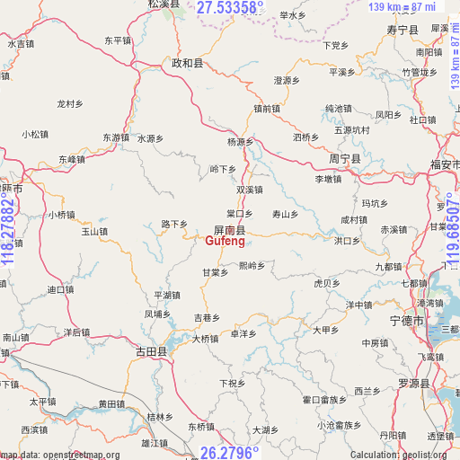
Gufeng GPS coordinates[2]
26° 54' 29.988" North, 118° 58' 54.984" East
| Map corner | latitude | longitude |
|---|---|---|
| Upper-left | 27.53358°, | 118.27882° |
| Center: | 26.90833°, | 118.98194° |
| Lower-right: | 26.2796°, | 119.68507° |
| Map W x H: | 139.4×139.4 km | = 86.6×86.6mi |
| max Lat: | 53.31946° ⇑79% North |
| Gufeng: | 26.90833° |
| min Lat: | ⇓21% South 18.22056° |
| min Long | Gufeng | max Long |
| 75.07348° | 118.98194° | 134.28917° |
| W 75.9%⇐ | ⇒24.1% E |
Elevation
Elevation of Gufeng is 831 m = 2726 ft, and this is 346.2 m = 1136 ft above average elevation for this country.
| Max E: |
5622 m = 18445 ft | 17.3% |
| Gufeng | 831 m 2726 ft | |
| Avg. | 484.8 m = 1591 ft | |
Min E: |
-3 m = -10 ft | 82.7% |
See also: China elevation on elevation.city.
Geographical zone
Gufeng is located in North temperate zone (between Tropic of Cancer and the Arctic Circle). Distance of this Northern Tropic circle is 386 km =239.8 mi to South.| Distance of | km | miles | from Gufeng |
|---|---|---|---|
| North Pole | 7015.1 | 4359 | to North |
| Arctic Circle | 4409.2 | 2739.7 | to North |
| Tropic Cancer | 386 | 239.8 | to South |
| Equator | 2991.9 | 1859.1 | to South |


Nearby cities:
15 places around Gufeng: (largest is in red/bold)
• Changqiao
16.8 km =10.4 mi,  234°
234°
• Daixi
16.9 km =10.5 mi,  129°
129°
• Gantang
13 km =8.1 mi,  200°
200°
• Hetang
30.1 km =18.7 mi,  154°
154°
• Jixiang
27.1 km =16.8 mi,  194°
194°
• Limen
27.2 km =16.9 mi,  55°
55°
• Lingxia
19 km =11.8 mi,  353°
353°
• Luxia
17.5 km =10.9 mi,  277°
277°
• Pinghu
26.8 km =16.7 mi,  224°
224°
• Shoushan
18.9 km =11.7 mi,  70°
70°
• Shuangxi
14 km =8.7 mi,  24°
24°
• Tangkou
5.9 km =3.7 mi,  30°
30°
• Xiling
12.3 km =7.6 mi, 148°
• Yangyuan
27.2 km =16.9 mi,  7°
7°
• Zhuoyang
31.2 km =19.4 mi,  172°
172°
Sources, notices
• [Note1] Compared only with cities in China existing in our database
• [Src1] Map data: © OpenStreetMap contributors (CC-BY-SA)
• [Src2] Other city data from geonames.org with taken over terms of usage.
• [Src3] Geographical zone / Annual Mean Temperature by Robert A. Rohde @ Wikipedia
