Guazhou geodata
Guazhou (Jiangsu) is a seat of a fourth-order administrative division; located in China in Asia/Shanghai (GMT+8) time zone. In our database, there are 1268 cities with bigger population. Compared to other cities in China, 62.7% of cities are located further ↓South; 78.1% of cities are located further ←West and 92.7% of cities have higher elevation than Guazhou. Note1


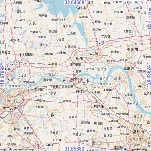
Guazhou GPS coordinates[2]
32° 15' 12.24" North, 119° 22' 59.196" East
| Map corner | latitude | longitude |
|---|---|---|
| Upper-left | 32.84608°, | 118.67999° |
| Center: | 32.2534°, | 119.38311° |
| Lower-right: | 31.65683°, | 120.08624° |
| Map W x H: | 132.2×132.2 km | = 82.1×82.1mi |
| max Lat: | 53.31946° ⇑37.3% North |
| Guazhou: | 32.2534° |
| min Lat: | ⇓62.7% South 18.22056° |
| min Long | Guazhou | max Long |
| 75.07348° | 119.38311° | 134.28917° |
| W 78.1%⇐ | ⇒21.9% E |
Elevation
Elevation of Guazhou is 8 m = 26 ft, and this is 476.8 m = 1564 ft below average elevation for this country.
| Max E: |
5622 m = 18445 ft | 92.7% |
| Avg. | 484.8 m = 1591 ft | |
| Guazhou | 8 m = 26 ft | |
Min E: |
-3 m = -10 ft | 7.3% |
See also: China elevation on elevation.city.
Geographical zone
Guazhou is located in North temperate zone (between Tropic of Cancer and the Arctic Circle). Distance of this Northern Tropic circle is 980.3 km =609.1 mi to South.| Distance of | km | miles | from Guazhou |
|---|---|---|---|
| North Pole | 6420.8 | 3989.7 | to North |
| Arctic Circle | 3814.9 | 2370.5 | to North |
| Tropic Cancer | 980.3 | 609.1 | to South |
| Equator | 3586.2 | 2228.4 | to South |


Nearby cities:
15 places around Guazhou: (largest is in red/bold)
• Bali
4.4 km =2.7 mi,  19°
19°
• Chahe
9.5 km =5.9 mi,  359°
359°
• Gaozi
12.1 km =7.5 mi,  219°
219°
• Guyang
14.2 km =8.8 mi,  157°
157°
• Hanshang
13.8 km =8.6 mi,  3°
3°
• Jiangqiao
12.8 km =8 mi,  145°
145°
• Jiangwang
12.4 km =7.7 mi,  354°
354°
• Poxi
8 km =5 mi,  306°
306°
• Qilidian
8.1 km =5 mi,  168°
168°
• Shatou
14.4 km =8.9 mi,  64°
64°
• Shiqiao
9.5 km =5.9 mi,  46°
46°
• Shiye
8.7 km =5.4 mi,  239°
239°
• Xinji
11.9 km =7.4 mi, 314°
• Zhengdonglu
10.6 km =6.6 mi,  129°
129°
• Zhenjiang
8.3 km =5.2 mi,  124°
124°
Sources, notices
• [Note1] Compared only with cities in China existing in our database
• [Src1] Map data: © OpenStreetMap contributors (CC-BY-SA)
• [Src2] Other city data from geonames.org with taken over terms of usage.
• [Src3] Geographical zone / Annual Mean Temperature by Robert A. Rohde @ Wikipedia
