Guanting geodata
Guanting (Qinghai) is a seat of a fourth-order administrative division; located in China in Asia/Shanghai (GMT+8) time zone. In our database, there are 1268 cities with bigger population. Compared to other cities in China, 76.9% of cities are located further ↓South; 91.9% of cities are located further →East and 93.9% of cities have lower elevation than Guanting. Note1


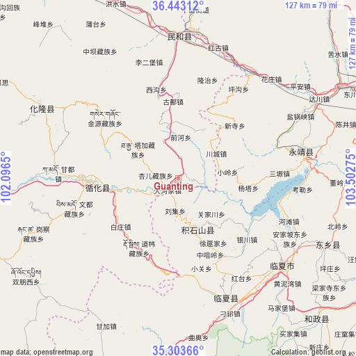
Guanting GPS coordinates[2]
35° 52' 31.584" North, 102° 47' 58.632" East
| Map corner | latitude | longitude |
|---|---|---|
| Upper-left | 36.44312°, | 102.0965° |
| Center: | 35.87544°, | 102.79962° |
| Lower-right: | 35.30366°, | 103.50275° |
| Map W x H: | 126.7×126.7 km | = 78.7×78.7mi |
| max Lat: | 53.31946° ⇑23.1% North |
| Guanting: | 35.87544° |
| min Lat: | ⇓76.9% South 18.22056° |
| min Long | Guanting | max Long |
| 75.07348° | 102.79962° | 134.28917° |
| W 8.1%⇐ | ⇒91.9% E |
Elevation
Elevation of Guanting is 1841 m = 6040 ft, and this is 1356.2 m = 4449 ft above average elevation for this country.
| Max E: |
5622 m = 18445 ft | 6.1% |
| Guanting | 1841 m 6040 ft | |
| Avg. | 484.8 m = 1591 ft | |
Min E: |
-3 m = -10 ft | 93.9% |
See also: China elevation on elevation.city.
Geographical zone
Guanting is located in North temperate zone (between Tropic of Cancer and the Arctic Circle). Distance of this Northern Tropic circle is 1383.1 km =859.4 mi to South.| Distance of | km | miles | from Guanting |
|---|---|---|---|
| North Pole | 6018.1 | 3739.5 | to North |
| Arctic Circle | 3412.2 | 2120.2 | to North |
| Tropic Cancer | 1383.1 | 859.4 | to South |
| Equator | 3989 | 2478.6 | to South |


Nearby cities:
15 places around Guanting: (largest is in red/bold)
• Baijiaji
18 km =11.2 mi,  305°
305°
• Chuimatan
18.7 km =11.6 mi,  159°
159°
• Dahejia
6 km =3.7 mi,  219°
219°
• Guanjiachuan
17.2 km =10.7 mi,  135°
135°
• Hulinjia
20.8 km =12.9 mi, 143°
• Lijiaping
12.2 km =7.6 mi,  345°
345°
• Liugou
15.4 km =9.6 mi, 161°
• Liuji
11.7 km =7.3 mi,  184°
184°
• Mengdadazhuang
15.2 km =9.4 mi,  252°
252°
• Shiyuan
13.7 km =8.5 mi, 177°
• Sibaozi
4.8 km =3 mi,  213°
213°
• Wangjia
14.8 km =9.2 mi,  4°
4°
• Xiaoling
17.8 km =11.1 mi,  83°
83°
• Xinjia
3.6 km =2.2 mi,  87°
87°
• Zhaizigou
23.3 km =14.5 mi, 159°
Sources, notices
• [Note1] Compared only with cities in China existing in our database
• [Src1] Map data: © OpenStreetMap contributors (CC-BY-SA)
• [Src2] Other city data from geonames.org with taken over terms of usage.
• [Src3] Geographical zone / Annual Mean Temperature by Robert A. Rohde @ Wikipedia
