Wangjia geodata
Wangjia (Qinghai) is a seat of a fourth-order administrative division; located in China in Asia/Shanghai (GMT+8) time zone. In our database, there are 1268 cities with bigger population. Compared to other cities in China, 77.2% of cities are located further ↓South; 91.8% of cities are located further →East and 95.3% of cities have lower elevation than Wangjia. Note1


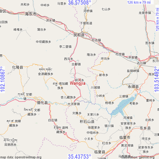
Wangjia GPS coordinates[2]
36° 0' 30.096" North, 102° 48' 42.444" East
| Map corner | latitude | longitude |
|---|---|---|
| Upper-left | 36.57508°, | 102.10867° |
| Center: | 36.00836°, | 102.81179° |
| Lower-right: | 35.43753°, | 103.51492° |
| Map W x H: | 126.5×126.5 km | = 78.6×78.6mi |
| max Lat: | 53.31946° ⇑22.8% North |
| Wangjia: | 36.00836° |
| min Lat: | ⇓77.2% South 18.22056° |
| min Long | Wangjia | max Long |
| 75.07348° | 102.81179° | 134.28917° |
| W 8.2%⇐ | ⇒91.8% E |
Elevation
Elevation of Wangjia is 2220 m = 7283 ft, and this is 1735.2 m = 5693 ft above average elevation for this country.
| Max E: |
5622 m = 18445 ft | 4.7% |
| Wangjia | 2220 m 7283 ft | |
| Avg. | 484.8 m = 1591 ft | |
Min E: |
-3 m = -10 ft | 95.3% |
See also: China elevation on elevation.city.
Geographical zone
Wangjia is located in North temperate zone (between Tropic of Cancer and the Arctic Circle). Distance of this Northern Tropic circle is 1397.8 km =868.6 mi to South.| Distance of | km | miles | from Wangjia |
|---|---|---|---|
| North Pole | 6003.3 | 3730.3 | to North |
| Arctic Circle | 3397.4 | 2111 | to North |
| Tropic Cancer | 1397.8 | 868.6 | to South |
| Equator | 4003.8 | 2487.8 | to South |


Nearby cities:
15 places around Wangjia: (largest is in red/bold)
• Baijiaji
16.2 km =10.1 mi,  254°
254°
• Chuimatan
32.8 km =20.4 mi,  170°
170°
• Dahejia
20 km =12.4 mi,  194°
194°
• Guanjiachuan
29.2 km =18.1 mi,  158°
158°
• Guanting
14.8 km =9.2 mi,  184°
184°
• Hulinjia
33.4 km =20.8 mi, 160°
• Lijiaping
5.1 km =3.2 mi,  233°
233°
• Liugou
29.6 km =18.4 mi, 172°
• Liuji
26.5 km =16.5 mi, 184°
• Mengdadazhuang
24.9 km =15.5 mi,  218°
218°
• Shixiang
31.3 km =19.4 mi, 231°
• Shiyuan
28.4 km =17.6 mi, 180°
• Sibaozi
19.2 km =11.9 mi, 191°
• Xiaoling
20.8 km =12.9 mi,  127°
127°
• Xinjia
14.8 km =9.2 mi, 170°
Sources, notices
• [Note1] Compared only with cities in China existing in our database
• [Src1] Map data: © OpenStreetMap contributors (CC-BY-SA)
• [Src2] Other city data from geonames.org with taken over terms of usage.
• [Src3] Geographical zone / Annual Mean Temperature by Robert A. Rohde @ Wikipedia
