Guangyubao geodata
Guangyubao (Shanxi) is a seat of a fourth-order administrative division; located in China in Asia/Shanghai (GMT+8) time zone. In our database, there are 1268 cities with bigger population. Compared to other cities in China, 83.7% of cities are located further ↓South; 54.9% of cities are located further →East and 86.3% of cities have lower elevation than Guangyubao. Note1


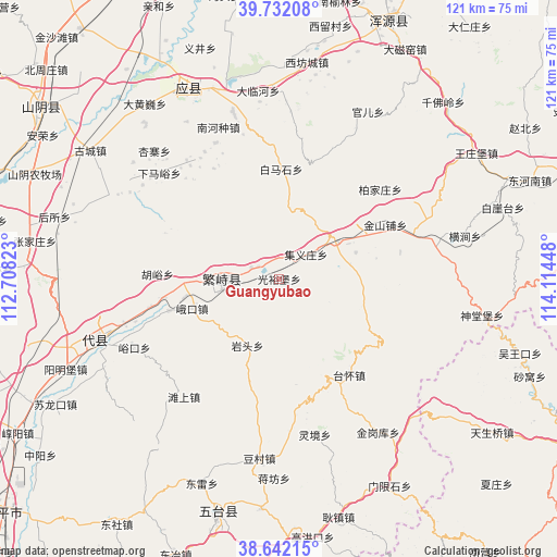
Guangyubao GPS coordinates[2]
39° 11' 21.228" North, 113° 24' 40.86" East
| Map corner | latitude | longitude |
|---|---|---|
| Upper-left | 39.73208°, | 112.70823° |
| Center: | 39.18923°, | 113.41135° |
| Lower-right: | 38.64215°, | 114.11448° |
| Map W x H: | 121.2×121.2 km | = 75.3×75.3mi |
| max Lat: | 53.31946° ⇑16.3% North |
| Guangyubao: | 39.18923° |
| min Lat: | ⇓83.7% South 18.22056° |
| min Long | Guangyubao | max Long |
| 75.07348° | 113.41135° | 134.28917° |
| W 45.1%⇐ | ⇒54.9% E |
Elevation
Elevation of Guangyubao is 1063 m = 3488 ft, and this is 578.2 m = 1897 ft above average elevation for this country.
| Max E: |
5622 m = 18445 ft | 13.7% |
| Guangyubao | 1063 m 3488 ft | |
| Avg. | 484.8 m = 1591 ft | |
Min E: |
-3 m = -10 ft | 86.3% |
See also: China elevation on elevation.city.
Geographical zone
Guangyubao is located in North temperate zone (between Tropic of Cancer and the Arctic Circle). Distance of this Northern Tropic circle is 1751.5 km =1088.3 mi to South.| Distance of | km | miles | from Guangyubao |
|---|---|---|---|
| North Pole | 5649.6 | 3510.5 | to North |
| Arctic Circle | 3043.7 | 1891.3 | to North |
| Tropic Cancer | 1751.5 | 1088.3 | to South |
| Equator | 4357.4 | 2707.6 | to South |


Nearby cities:
15 places around Guangyubao: (largest is in red/bold)
• Baijiazhuang
29.3 km =18.2 mi,  48°
48°
• Daying
31.9 km =19.8 mi,  69°
69°
• Ekou
20 km =12.4 mi,  251°
251°
• Fanshi
12.7 km =7.9 mi,  270°
270°
• Huyu
26.6 km =16.5 mi, 272°
• Jinshanpu
25.9 km =16.1 mi,  63°
63°
• Jiyizhuang
7.9 km =4.9 mi, 47°
• Nanquan
32.7 km =20.3 mi,  321°
321°
• Nieying
25 km =15.5 mi, 253°
• Shahe
14.8 km =9.2 mi, 52°
• Xiaruyue
5.3 km =3.3 mi,  298°
298°
• Xicun
25.9 km =16.1 mi,  260°
260°
• Xingyuan
12.5 km =7.8 mi, 259°
• Yanglinjie
25.3 km =15.7 mi,  142°
142°
• Yantou
16 km =9.9 mi,  206°
206°
Sources, notices
• [Note1] Compared only with cities in China existing in our database
• [Src1] Map data: © OpenStreetMap contributors (CC-BY-SA)
• [Src2] Other city data from geonames.org with taken over terms of usage.
• [Src3] Geographical zone / Annual Mean Temperature by Robert A. Rohde @ Wikipedia
