Shahe geodata
Shahe (Shanxi) is a seat of a fourth-order administrative division; located in China in Asia/Shanghai (GMT+8) time zone. In our database, there are 1268 cities with bigger population. Compared to other cities in China, 84% of cities are located further ↓South; 54% of cities are located further →East and 86.5% of cities have lower elevation than Shahe. Note1


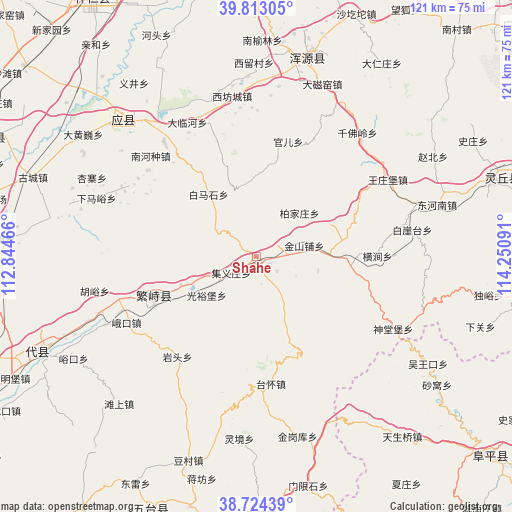
Shahe GPS coordinates[2]
39° 16' 14.988" North, 113° 32' 52.008" East
| Map corner | latitude | longitude |
|---|---|---|
| Upper-left | 39.81305°, | 112.84466° |
| Center: | 39.27083°, | 113.54778° |
| Lower-right: | 38.72439°, | 114.25091° |
| Map W x H: | 121×121 km | = 75.2×75.2mi |
| max Lat: | 53.31946° ⇑16% North |
| Shahe: | 39.27083° |
| min Lat: | ⇓84% South 18.22056° |
| min Long | Shahe | max Long |
| 75.07348° | 113.54778° | 134.28917° |
| W 46%⇐ | ⇒54% E |
Elevation
Elevation of Shahe is 1081 m = 3547 ft, and this is 596.2 m = 1956 ft above average elevation for this country.
| Max E: |
5622 m = 18445 ft | 13.5% |
| Shahe | 1081 m 3547 ft | |
| Avg. | 484.8 m = 1591 ft | |
Min E: |
-3 m = -10 ft | 86.5% |
See also: China elevation on elevation.city.
Geographical zone
Shahe is located in North temperate zone (between Tropic of Cancer and the Arctic Circle). Distance of this Northern Tropic circle is 1760.6 km =1094 mi to South.| Distance of | km | miles | from Shahe |
|---|---|---|---|
| North Pole | 5640.6 | 3504.9 | to North |
| Arctic Circle | 3034.7 | 1885.7 | to North |
| Tropic Cancer | 1760.6 | 1094 | to South |
| Equator | 4366.5 | 2713.2 | to South |


Nearby cities:
15 places around Shahe: (largest is in red/bold)
• Baijiazhuang
14.6 km =9.1 mi,  44°
44°
• Daying
18.2 km =11.3 mi,  83°
83°
• Ekou
34.4 km =21.4 mi,  243°
243°
• Fanshi
26 km =16.2 mi,  249°
249°
• Guangyubao
14.8 km =9.2 mi,  232°
232°
• Guan’er
28.3 km =17.6 mi,  15°
15°
• Hengjian
28.6 km =17.8 mi,  89°
89°
• Jinshanpu
11.6 km =7.2 mi, 76°
• Jiyizhuang
7 km =4.3 mi, 237°
• Nanhezhong
34.5 km =21.4 mi,  313°
313°
• Xiaruyue
17.7 km =11 mi, 248°
• Xiashe
34.8 km =21.6 mi,  321°
321°
• Xingyuan
26.5 km =16.5 mi, 244°
• Yanglinjie
29.4 km =18.3 mi,  172°
172°
• Yantou
30 km =18.6 mi,  218°
218°
Sources, notices
• [Note1] Compared only with cities in China existing in our database
• [Src1] Map data: © OpenStreetMap contributors (CC-BY-SA)
• [Src2] Other city data from geonames.org with taken over terms of usage.
• [Src3] Geographical zone / Annual Mean Temperature by Robert A. Rohde @ Wikipedia
