Gongdao geodata
Gongdao (Jiangsu) is a seat of a fourth-order administrative division; located in China in Asia/Shanghai (GMT+8) time zone. In our database, there are 1268 cities with bigger population. Compared to other cities in China, 64.3% of cities are located further ↓South; 77.9% of cities are located further ←West and 87.7% of cities have higher elevation than Gongdao. Note1


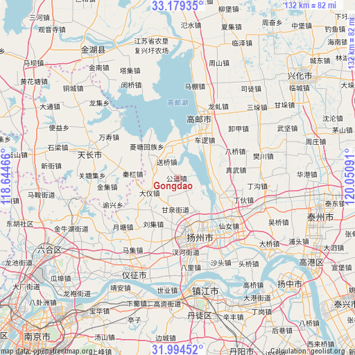
Gongdao GPS coordinates[2]
32° 35' 20.004" North, 119° 20' 52.008" East
| Map corner | latitude | longitude |
|---|---|---|
| Upper-left | 33.17935°, | 118.64466° |
| Center: | 32.58889°, | 119.34778° |
| Lower-right: | 31.99452°, | 120.05091° |
| Map W x H: | 131.7×131.7 km | = 81.8×81.8mi |
| max Lat: | 53.31946° ⇑35.7% North |
| Gongdao: | 32.58889° |
| min Lat: | ⇓64.3% South 18.22056° |
| min Long | Gongdao | max Long |
| 75.07348° | 119.34778° | 134.28917° |
| W 77.9%⇐ | ⇒22.1% E |
Elevation
Elevation of Gongdao is 12 m = 39 ft, and this is 472.8 m = 1551 ft below average elevation for this country.
| Max E: |
5622 m = 18445 ft | 87.7% |
| Avg. | 484.8 m = 1591 ft | |
| Gongdao | 12 m = 39 ft | |
Min E: |
-3 m = -10 ft | 12.3% |
See also: China elevation on elevation.city.
Geographical zone
Gongdao is located in North temperate zone (between Tropic of Cancer and the Arctic Circle). Distance of this Northern Tropic circle is 1017.6 km =632.3 mi to South.| Distance of | km | miles | from Gongdao |
|---|---|---|---|
| North Pole | 6383.5 | 3966.5 | to North |
| Arctic Circle | 3777.6 | 2347.3 | to North |
| Tropic Cancer | 1017.6 | 632.3 | to South |
| Equator | 3623.5 | 2251.5 | to South |


Nearby cities:
15 places around Gongdao: (largest is in red/bold)
• Cheluo
17.1 km =10.6 mi,  34°
34°
• Chenji
19.1 km =11.9 mi,  232°
232°
• Dayi
11.5 km =7.1 mi,  243°
243°
• Fangxiang
10 km =6.2 mi,  159°
159°
• Ganquan
12 km =7.5 mi,  182°
182°
• Guoji
12.3 km =7.6 mi,  350°
350°
• Lingtang
16 km =9.9 mi,  315°
315°
• Pingshan
18.7 km =11.6 mi, 163°
• Qinlan
17 km =10.6 mi,  274°
274°
• Shaobo
16.2 km =10.1 mi,  113°
113°
• Shouxihu
19.4 km =12.1 mi, 164°
• Songqiao
7.3 km =4.5 mi,  325°
325°
• Tianshan
10.1 km =6.3 mi,  292°
292°
• Xihu
18.6 km =11.6 mi,  166°
166°
• Yangmiao
19.3 km =12 mi,  185°
185°
Sources, notices
• [Note1] Compared only with cities in China existing in our database
• [Src1] Map data: © OpenStreetMap contributors (CC-BY-SA)
• [Src2] Other city data from geonames.org with taken over terms of usage.
• [Src3] Geographical zone / Annual Mean Temperature by Robert A. Rohde @ Wikipedia
