Gecheng geodata
Gecheng (Chongqing) is a seat of a third-order administrative division; located in China in Asia/Shanghai (GMT+8) time zone. In our database, there are 1268 cities with bigger population. Compared to other cities in China, 60.9% of cities are located further ↓South; 77.9% of cities are located further →East and 81.4% of cities have lower elevation than Gecheng. Note1


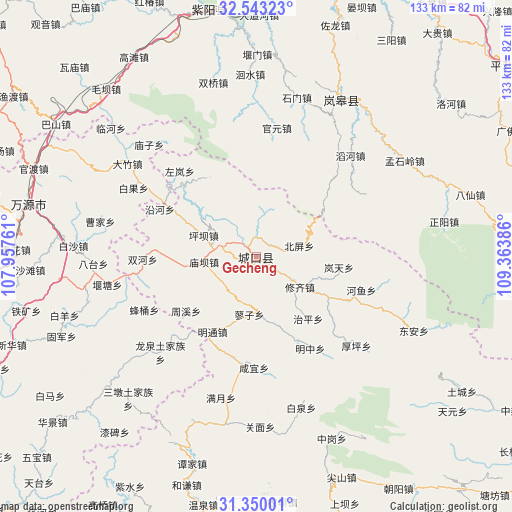
Gecheng GPS coordinates[2]
31° 56' 54.816" North, 108° 39' 38.628" East
| Map corner | latitude | longitude |
|---|---|---|
| Upper-left | 32.54323°, | 107.95761° |
| Center: | 31.94856°, | 108.66073° |
| Lower-right: | 31.35001°, | 109.36386° |
| Map W x H: | 132.7×132.7 km | = 82.5×82.5mi |
| max Lat: | 53.31946° ⇑39.1% North |
| Gecheng: | 31.94856° |
| min Lat: | ⇓60.9% South 18.22056° |
| min Long | Gecheng | max Long |
| 75.07348° | 108.66073° | 134.28917° |
| W 22.1%⇐ | ⇒77.9% E |
Elevation
Elevation of Gecheng is 761 m = 2497 ft, and this is 276.2 m = 906 ft above average elevation for this country.
| Max E: |
5622 m = 18445 ft | 18.6% |
| Gecheng | 761 m 2497 ft | |
| Avg. | 484.8 m = 1591 ft | |
Min E: |
-3 m = -10 ft | 81.4% |
See also: China elevation on elevation.city.
Geographical zone
Gecheng is located in North temperate zone (between Tropic of Cancer and the Arctic Circle). Distance of this Northern Tropic circle is 946.4 km =588.1 mi to South.| Distance of | km | miles | from Gecheng |
|---|---|---|---|
| North Pole | 6454.7 | 4010.8 | to North |
| Arctic Circle | 3848.8 | 2391.5 | to North |
| Tropic Cancer | 946.4 | 588.1 | to South |
| Equator | 3552.3 | 2207.3 | to South |


Nearby cities:
15 places around Gecheng: (largest is in red/bold)
• Bashan
25.7 km =16 mi,  314°
314°
• Beiping
11.5 km =7.1 mi,  75°
75°
• Gaoguan
24.4 km =15.2 mi,  116°
116°
• Gaonan
24.7 km =15.3 mi,  326°
326°
• Gaoyan
4.1 km =2.5 mi,  249°
249°
• Jiwu
26.7 km =16.6 mi,  192°
192°
• Lantian
21.6 km =13.4 mi,  97°
97°
• Liaozi
15.1 km =9.4 mi, 186°
• Longtian
3.8 km =2.4 mi,  319°
319°
• Miaoba
13.6 km =8.5 mi,  264°
264°
• Mingtong
22.5 km =14 mi,  210°
210°
• Pingba
14.6 km =9.1 mi,  292°
292°
• Xiuqi
13.9 km =8.6 mi, 124°
• Yanhe
27.8 km =17.3 mi,  296°
296°
• Zhouxi
22.7 km =14.1 mi,  229°
229°
Sources, notices
• [Note1] Compared only with cities in China existing in our database
• [Src1] Map data: © OpenStreetMap contributors (CC-BY-SA)
• [Src2] Other city data from geonames.org with taken over terms of usage.
• [Src3] Geographical zone / Annual Mean Temperature by Robert A. Rohde @ Wikipedia
