Lantian geodata
Lantian (Chongqing) is a seat of a fourth-order administrative division; located in China in Asia/Shanghai (GMT+8) time zone. In our database, there are 1268 cities with bigger population. Compared to other cities in China, 60.7% of cities are located further ↓South; 76.9% of cities are located further →East and 87.8% of cities have lower elevation than Lantian. Note1


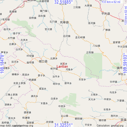
Lantian GPS coordinates[2]
31° 55' 26.472" North, 108° 53' 16.44" East
| Map corner | latitude | longitude |
|---|---|---|
| Upper-left | 32.51885°, | 108.18478° |
| Center: | 31.92402°, | 108.8879° |
| Lower-right: | 31.32531°, | 109.59103° |
| Map W x H: | 132.7×132.7 km | = 82.5×82.5mi |
| max Lat: | 53.31946° ⇑39.3% North |
| Lantian: | 31.92402° |
| min Lat: | ⇓60.7% South 18.22056° |
| min Long | Lantian | max Long |
| 75.07348° | 108.8879° | 134.28917° |
| W 23.1%⇐ | ⇒76.9% E |
Elevation
Elevation of Lantian is 1170 m = 3839 ft, and this is 685.2 m = 2248 ft above average elevation for this country.
| Max E: |
5622 m = 18445 ft | 12.2% |
| Lantian | 1170 m 3839 ft | |
| Avg. | 484.8 m = 1591 ft | |
Min E: |
-3 m = -10 ft | 87.8% |
See also: China elevation on elevation.city.
Geographical zone
Lantian is located in North temperate zone (between Tropic of Cancer and the Arctic Circle). Distance of this Northern Tropic circle is 943.7 km =586.4 mi to South.| Distance of | km | miles | from Lantian |
|---|---|---|---|
| North Pole | 6457.4 | 4012.4 | to North |
| Arctic Circle | 3851.6 | 2393.3 | to North |
| Tropic Cancer | 943.7 | 586.4 | to South |
| Equator | 3549.6 | 2205.6 | to South |


Nearby cities:
15 places around Lantian: (largest is in red/bold)
• Beiping
11.7 km =7.3 mi,  298°
298°
• Dong’an
24.8 km =15.4 mi,  131°
131°
• Gaoguan
8.3 km =5.2 mi,  178°
178°
• Gaoyan
25.3 km =15.7 mi,  272°
272°
• Gecheng
21.6 km =13.4 mi,  277°
277°
• Heyu
8.3 km =5.2 mi,  135°
135°
• Houping
20.9 km =13 mi,  167°
167°
• Jiwu
36 km =22.4 mi,  229°
229°
• Liaozi
26.2 km =16.3 mi,  242°
242°
• Longtian
24.5 km =15.2 mi, 283°
• Miaoba
34.9 km =21.7 mi, 272°
• Mingzhong
22.3 km =13.9 mi,  197°
197°
• Pingba
35.9 km =22.3 mi, 283°
• Xianyi
34.2 km =21.3 mi,  220°
220°
• Xiuqi
11.3 km =7 mi, 242°
Sources, notices
• [Note1] Compared only with cities in China existing in our database
• [Src1] Map data: © OpenStreetMap contributors (CC-BY-SA)
• [Src2] Other city data from geonames.org with taken over terms of usage.
• [Src3] Geographical zone / Annual Mean Temperature by Robert A. Rohde @ Wikipedia
