Beiping geodata
Beiping (Chongqing) is a seat of a fourth-order administrative division; located in China in Asia/Shanghai (GMT+8) time zone. In our database, there are 1268 cities with bigger population. Compared to other cities in China, 61% of cities are located further ↓South; 77.3% of cities are located further →East and 87.1% of cities have lower elevation than Beiping. Note1


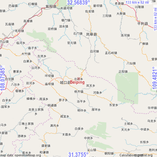
Beiping GPS coordinates[2]
31° 58' 25.968" North, 108° 46' 44.292" East
| Map corner | latitude | longitude |
|---|---|---|
| Upper-left | 32.56839°, | 108.07585° |
| Center: | 31.97388°, | 108.77897° |
| Lower-right: | 31.3755°, | 109.4821° |
| Map W x H: | 132.6×132.6 km | = 82.4×82.4mi |
| max Lat: | 53.31946° ⇑39% North |
| Beiping: | 31.97388° |
| min Lat: | ⇓61% South 18.22056° |
| min Long | Beiping | max Long |
| 75.07348° | 108.77897° | 134.28917° |
| W 22.7%⇐ | ⇒77.3% E |
Elevation
Elevation of Beiping is 1119 m = 3671 ft, and this is 634.2 m = 2081 ft above average elevation for this country.
| Max E: |
5622 m = 18445 ft | 12.9% |
| Beiping | 1119 m 3671 ft | |
| Avg. | 484.8 m = 1591 ft | |
Min E: |
-3 m = -10 ft | 87.1% |
See also: China elevation on elevation.city.
Geographical zone
Beiping is located in North temperate zone (between Tropic of Cancer and the Arctic Circle). Distance of this Northern Tropic circle is 949.2 km =589.8 mi to South.| Distance of | km | miles | from Beiping |
|---|---|---|---|
| North Pole | 6451.9 | 4009 | to North |
| Arctic Circle | 3846 | 2389.8 | to North |
| Tropic Cancer | 949.2 | 589.8 | to South |
| Equator | 3555.2 | 2209.1 | to South |


Nearby cities:
15 places around Beiping: (largest is in red/bold)
• Bashan
33.1 km =20.6 mi,  297°
297°
• Gaoguan
17.4 km =10.8 mi,  142°
142°
• Gaonan
30.5 km =19 mi,  305°
305°
• Gaoyan
15.6 km =9.7 mi,  254°
254°
• Gecheng
11.5 km =7.1 mi,  255°
255°
• Heyu
19.7 km =12.2 mi,  125°
125°
• Houping
29.9 km =18.6 mi,  150°
150°
• Lantian
11.7 km =7.3 mi,  118°
118°
• Liaozi
22 km =13.7 mi,  215°
215°
• Longtian
13.6 km =8.5 mi,  270°
270°
• Miaoba
25 km =15.5 mi, 260°
• Mingtong
31.7 km =19.7 mi,  225°
225°
• Mingzhong
27 km =16.8 mi,  172°
172°
• Pingba
24.8 km =15.4 mi,  276°
276°
• Xiuqi
10.7 km =6.6 mi,  178°
178°
Sources, notices
• [Note1] Compared only with cities in China existing in our database
• [Src1] Map data: © OpenStreetMap contributors (CC-BY-SA)
• [Src2] Other city data from geonames.org with taken over terms of usage.
• [Src3] Geographical zone / Annual Mean Temperature by Robert A. Rohde @ Wikipedia
