Gaoliang geodata
Gaoliang (Guangdong) is a seat of a fourth-order administrative division; located in China in Asia/Shanghai (GMT+8) time zone. In our database, there are 1268 cities with bigger population. Compared to other cities in China, 93.1% of cities are located further ↑North; 63% of cities are located further →East and 62.4% of cities have higher elevation than Gaoliang. Note1


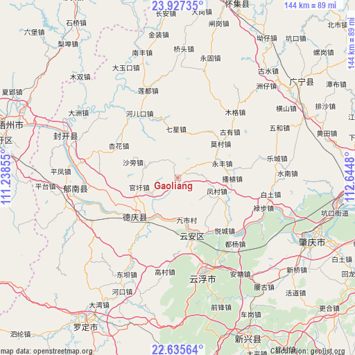
Gaoliang GPS coordinates[2]
23° 16' 59.016" North, 111° 56' 30.012" East
| Map corner | latitude | longitude |
|---|---|---|
| Upper-left | 23.92735°, | 111.23855° |
| Center: | 23.28306°, | 111.94167° |
| Lower-right: | 22.63564°, | 112.6448° |
| Map W x H: | 143.6×143.6 km | = 89.2×89.2mi |
| max Lat: | 53.31946° ⇑93.1% North |
| Gaoliang: | 23.28306° |
| min Lat: | ⇓6.9% South 18.22056° |
| min Long | Gaoliang | max Long |
| 75.07348° | 111.94167° | 134.28917° |
| W 37%⇐ | ⇒63% E |
Elevation
Elevation of Gaoliang is 85 m = 279 ft, and this is 399.8 m = 1312 ft below average elevation for this country.
| Max E: |
5622 m = 18445 ft | 62.4% |
| Avg. | 484.8 m = 1591 ft | |
| Gaoliang | 85 m = 279 ft | |
Min E: |
-3 m = -10 ft | 37.6% |
See also: China elevation on elevation.city.
Geographical zone
Gaoliang is located in North Torrid zone (between Equator and Tropic of Cancer). Distance of this Northern Tropic circle is 17.1 km =10.6 mi to North.| Distance of | km | miles | from Gaoliang |
|---|---|---|---|
| North Pole | 7418.2 | 4609.5 | to North |
| Arctic Circle | 4812.3 | 2990.2 | to North |
| Tropic Cancer | 17.1 | 10.6 | to North |
| Equator | 2588.8 | 1608.6 | to South |


Nearby cities:
15 places around Gaoliang: (largest is in red/bold)
• Bozhi
22.3 km =13.9 mi,  92°
92°
• Decheng
22.7 km =14.1 mi,  226°
226°
• Fengcun
16.5 km =10.3 mi,  109°
109°
• Guanxu
15.4 km =9.6 mi,  258°
258°
• Huilong
27.8 km =17.3 mi,  247°
247°
• Jiushi
16.5 km =10.3 mi,  169°
169°
• Liudu
23.7 km =14.7 mi,  164°
164°
• Maxu
11.7 km =7.3 mi, 245°
• Mocun
22 km =13.7 mi,  50°
50°
• Nanjiangkou
22.1 km =13.7 mi,  217°
217°
• Wulong
25.5 km =15.8 mi,  79°
79°
• Xinghua
26.4 km =16.4 mi,  299°
299°
• Xinxu
22.2 km =13.8 mi,  235°
235°
• Yongfeng
19.3 km =12 mi,  70°
70°
• Yuecheng
28.6 km =17.8 mi,  138°
138°
Sources, notices
• [Note1] Compared only with cities in China existing in our database
• [Src1] Map data: © OpenStreetMap contributors (CC-BY-SA)
• [Src2] Other city data from geonames.org with taken over terms of usage.
• [Src3] Geographical zone / Annual Mean Temperature by Robert A. Rohde @ Wikipedia
