Decheng geodata
Decheng (Guangdong) is a seat of a third-order administrative division; located in China in Asia/Shanghai (GMT+8) time zone. In our database, there are 1268 cities with bigger population. Compared to other cities in China, 93.7% of cities are located further ↑North; 63.6% of cities are located further →East and 86.9% of cities have higher elevation than Decheng. Note1


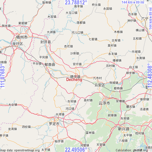
Decheng GPS coordinates[2]
23° 8' 35.34" North, 111° 46' 47.82" East
| Map corner | latitude | longitude |
|---|---|---|
| Upper-left | 23.78812°, | 111.07683° |
| Center: | 23.14315°, | 111.77995° |
| Lower-right: | 22.49506°, | 112.48308° |
| Map W x H: | 143.8×143.8 km | = 89.4×89.4mi |
| max Lat: | 53.31946° ⇑93.7% North |
| Decheng: | 23.14315° |
| min Lat: | ⇓6.3% South 18.22056° |
| min Long | Decheng | max Long |
| 75.07348° | 111.77995° | 134.28917° |
| W 36.4%⇐ | ⇒63.6% E |
Elevation
Elevation of Decheng is 13 m = 43 ft, and this is 471.8 m = 1548 ft below average elevation for this country.
| Max E: |
5622 m = 18445 ft | 86.9% |
| Avg. | 484.8 m = 1591 ft | |
| Decheng | 13 m = 43 ft | |
Min E: |
-3 m = -10 ft | 13.1% |
See also: China elevation on elevation.city.
Geographical zone
Decheng is located in North Torrid zone (between Equator and Tropic of Cancer). Distance of this Northern Tropic circle is 32.6 km =20.3 mi to North.| Distance of | km | miles | from Decheng |
|---|---|---|---|
| North Pole | 7433.8 | 4619.1 | to North |
| Arctic Circle | 4827.9 | 2999.9 | to North |
| Tropic Cancer | 32.6 | 20.3 | to North |
| Equator | 2573.3 | 1599 | to South |


Nearby cities:
15 places around Decheng: (largest is in red/bold)
• Baozhu
17.7 km =11 mi,  259°
259°
• Changgang
25.4 km =15.8 mi,  306°
306°
• Dongba
22.7 km =14.1 mi,  187°
187°
• Gaocun
24.7 km =15.3 mi,  153°
153°
• Gaoliang
22.7 km =14.1 mi,  46°
46°
• Guanxu
12.7 km =7.9 mi,  6°
6°
• Huilong
10.4 km =6.5 mi,  298°
298°
• Jiancheng
24.7 km =15.3 mi,  268°
268°
• Jiushi
19.4 km =12.1 mi,  91°
91°
• Liantan
23.8 km =14.8 mi, 193°
• Lidong
22.2 km =13.8 mi,  212°
212°
• Liudu
24 km =14.9 mi,  107°
107°
• Maxu
12.2 km =7.6 mi,  28°
28°
• Nanjiangkou
3.6 km =2.2 mi,  122°
122°
• Xinxu
3.4 km =2.1 mi,  328°
328°
Sources, notices
• [Note1] Compared only with cities in China existing in our database
• [Src1] Map data: © OpenStreetMap contributors (CC-BY-SA)
• [Src2] Other city data from geonames.org with taken over terms of usage.
• [Src3] Geographical zone / Annual Mean Temperature by Robert A. Rohde @ Wikipedia
