Nanjiangkou geodata
Nanjiangkou (Guangdong) is a seat of a fourth-order administrative division; located in China in Asia/Shanghai (GMT+8) time zone. In our database, there are 1268 cities with bigger population. Compared to other cities in China, 93.8% of cities are located further ↑North; 63.5% of cities are located further →East and 68.2% of cities have higher elevation than Nanjiangkou. Note1


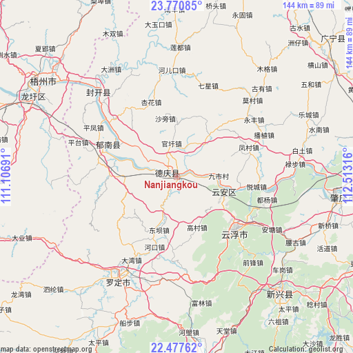
Nanjiangkou GPS coordinates[2]
23° 7' 32.844" North, 111° 48' 36.108" East
| Map corner | latitude | longitude |
|---|---|---|
| Upper-left | 23.77085°, | 111.10691° |
| Center: | 23.12579°, | 111.81003° |
| Lower-right: | 22.47762°, | 112.51316° |
| Map W x H: | 143.8×143.8 km | = 89.4×89.4mi |
| max Lat: | 53.31946° ⇑93.8% North |
| Nanjiangkou: | 23.12579° |
| min Lat: | ⇓6.2% South 18.22056° |
| min Long | Nanjiangkou | max Long |
| 75.07348° | 111.81003° | 134.28917° |
| W 36.5%⇐ | ⇒63.5% E |
Elevation
Elevation of Nanjiangkou is 59 m = 194 ft, and this is 425.8 m = 1397 ft below average elevation for this country.
| Max E: |
5622 m = 18445 ft | 68.2% |
| Avg. | 484.8 m = 1591 ft | |
| Nanjiangkou | 59 m = 194 ft | |
Min E: |
-3 m = -10 ft | 31.8% |
See also: China elevation on elevation.city.
Geographical zone
Nanjiangkou is located in North Torrid zone (between Equator and Tropic of Cancer). Distance of this Northern Tropic circle is 34.6 km =21.5 mi to North.| Distance of | km | miles | from Nanjiangkou |
|---|---|---|---|
| North Pole | 7435.7 | 4620.3 | to North |
| Arctic Circle | 4829.8 | 3001.1 | to North |
| Tropic Cancer | 34.6 | 21.5 | to North |
| Equator | 2571.3 | 1597.7 | to South |


Nearby cities:
15 places around Nanjiangkou: (largest is in red/bold)
• Baozhu
20.5 km =12.7 mi,  266°
266°
• Decheng
3.6 km =2.2 mi,  302°
302°
• Dongba
21.5 km =13.4 mi,  196°
196°
• Gaocun
21.7 km =13.5 mi,  158°
158°
• Gaoliang
22.1 km =13.7 mi,  37°
37°
• Guanxu
14.6 km =9.1 mi,  353°
353°
• Huilong
14.1 km =8.8 mi, 299°
• Jiancheng
27.8 km =17.3 mi, 272°
• Jiushi
16.4 km =10.2 mi,  85°
85°
• Liantan
23 km =14.3 mi, 202°
• Lidong
22.6 km =14 mi,  222°
222°
• Liudu
20.5 km =12.7 mi,  105°
105°
• Maxu
13 km =8.1 mi,  12°
12°
• Songgui
25.2 km =15.7 mi,  190°
190°
• Xinxu
6.8 km =4.2 mi,  315°
315°
Sources, notices
• [Note1] Compared only with cities in China existing in our database
• [Src1] Map data: © OpenStreetMap contributors (CC-BY-SA)
• [Src2] Other city data from geonames.org with taken over terms of usage.
• [Src3] Geographical zone / Annual Mean Temperature by Robert A. Rohde @ Wikipedia
