Gaojingzhuang geodata
Gaojingzhuang (Tianjin) is a populated place; located in China in Asia/Shanghai (GMT+8) time zone. With population of 1,167 people, there are 1141 cities with bigger population in this country. Compared to other cities in China, 84.4% of cities are located further ↓South; 69.2% of cities are located further ←West and 97.2% of cities have higher elevation than Gaojingzhuang. Note1


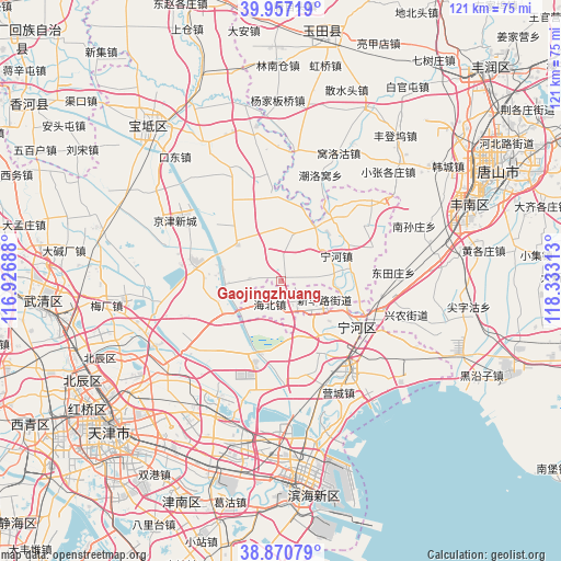
Gaojingzhuang GPS coordinates[2]
39° 24' 57.996" North, 117° 37' 48" East
| Map corner | latitude | longitude |
|---|---|---|
| Upper-left | 39.95719°, | 116.92688° |
| Center: | 39.41611°, | 117.63° |
| Lower-right: | 38.87079°, | 118.33313° |
| Map W x H: | 120.8×120.8 km | = 75.1×75.1mi |
| max Lat: | 53.31946° ⇑15.6% North |
| Gaojingzhuang: | 39.41611° |
| min Lat: | ⇓84.4% South 18.22056° |
| min Long | Gaojingzhuang | max Long |
| 75.07348° | 117.63° | 134.28917° |
| W 69.2%⇐ | ⇒30.8% E |
Elevation
Elevation of Gaojingzhuang is 5 m = 16 ft, and this is 479.8 m = 1574 ft below average elevation for this country.
| Max E: |
5622 m = 18445 ft | 97.2% |
| Avg. | 484.8 m = 1591 ft | |
| Gaojingzhuang | 5 m = 16 ft | |
Min E: |
-3 m = -10 ft | 2.8% |
See also: China elevation on elevation.city.
Geographical zone
Gaojingzhuang is located in North temperate zone (between Tropic of Cancer and the Arctic Circle). Distance of this Northern Tropic circle is 1776.7 km =1104 mi to South.| Distance of | km | miles | from Gaojingzhuang |
|---|---|---|---|
| North Pole | 5624.4 | 3494.8 | to North |
| Arctic Circle | 3018.5 | 1875.6 | to North |
| Tropic Cancer | 1776.7 | 1104 | to South |
| Equator | 4382.7 | 2723.3 | to South |


Nearby cities:
15 places around Gaojingzhuang: (largest is in red/bold)
• Biaokou
12 km =7.5 mi,  212°
212°
• Dadengzhuang
7.9 km =4.9 mi,  352°
352°
• Daxinzhuang
10.9 km =6.8 mi,  26°
26°
• Dongjituo
4.8 km =3 mi,  277°
277°
• Duli
12.2 km =7.6 mi,  155°
155°
• Huangzhuang
12.4 km =7.7 mi,  306°
306°
• Jiangwakou
13.4 km =8.3 mi, 27°
• Lianzhuang
10.9 km =6.8 mi,  93°
93°
• Miaozhuang
15 km =9.3 mi, 87°
• Nanmaizhu
13.8 km =8.6 mi,  45°
45°
• Ninghe
12.5 km =7.8 mi,  65°
65°
• Qiaogu
14.1 km =8.8 mi,  144°
144°
• Renfengzhuang
12 km =7.5 mi,  166°
166°
• Xitangtuo
16 km =9.9 mi,  229°
229°
• Zhaobenzhuang
5.3 km =3.3 mi,  2°
2°
Sources, notices
• [Note1] Compared only with cities in China existing in our database
• [Src1] Map data: © OpenStreetMap contributors (CC-BY-SA)
• [Src2] Other city data from geonames.org with taken over terms of usage.
• [Src3] Geographical zone / Annual Mean Temperature by Robert A. Rohde @ Wikipedia
