Biaokou geodata
Biaokou (Tianjin) is a seat of a fourth-order administrative division; located in China in Asia/Shanghai (GMT+8) time zone. With population of 8,120 people, there are 829 cities with bigger population in this country. Compared to other cities in China, 84.2% of cities are located further ↓South; 69% of cities are located further ←West and 94.3% of cities have higher elevation than Biaokou. Note1


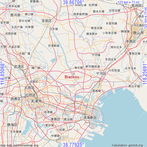
Biaokou GPS coordinates[2]
39° 19' 30.972" North, 117° 33' 13.608" East
| Map corner | latitude | longitude |
|---|---|---|
| Upper-left | 39.86706°, | 116.85066° |
| Center: | 39.32527°, | 117.55378° |
| Lower-right: | 38.77925°, | 118.25691° |
| Map W x H: | 121×121 km | = 75.2×75.2mi |
| max Lat: | 53.31946° ⇑15.8% North |
| Biaokou: | 39.32527° |
| min Lat: | ⇓84.2% South 18.22056° |
| min Long | Biaokou | max Long |
| 75.07348° | 117.55378° | 134.28917° |
| W 69%⇐ | ⇒31% E |
Elevation
Elevation of Biaokou is 7 m = 23 ft, and this is 477.8 m = 1568 ft below average elevation for this country.
| Max E: |
5622 m = 18445 ft | 94.3% |
| Avg. | 484.8 m = 1591 ft | |
| Biaokou | 7 m = 23 ft | |
Min E: |
-3 m = -10 ft | 5.7% |
See also: China elevation on elevation.city.
Geographical zone
Biaokou is located in North temperate zone (between Tropic of Cancer and the Arctic Circle). Distance of this Northern Tropic circle is 1766.6 km =1097.7 mi to South.| Distance of | km | miles | from Biaokou |
|---|---|---|---|
| North Pole | 5634.5 | 3501.1 | to North |
| Arctic Circle | 3028.6 | 1881.9 | to North |
| Tropic Cancer | 1766.6 | 1097.7 | to South |
| Equator | 4372.6 | 2717 | to South |


Nearby cities:
15 places around Biaokou: (largest is in red/bold)
• Beihuaidian
7.5 km =4.7 mi,  173°
173°
• Datangzhuang
13.2 km =8.2 mi,  308°
308°
• Datianzhuang
18.2 km =11.3 mi,  108°
108°
• Dawangtai
8.1 km =5 mi,  226°
226°
• Dongditou
16.9 km =10.5 mi,  247°
247°
• Dongjituo
10.9 km =6.8 mi,  9°
9°
• Duli
11.7 km =7.3 mi,  94°
94°
• Gaojingzhuang
12 km =7.5 mi,  32°
32°
• Huangzhuang
17.7 km =11 mi,  348°
348°
• Panzhuang
7.5 km =4.7 mi,  282°
282°
• Qiaogu
14.8 km =9.2 mi,  95°
95°
• Renfengzhuang
9.5 km =5.9 mi, 99°
• Xitangtuo
5.6 km =3.5 mi,  266°
266°
• Zaojiacheng
11.5 km =7.1 mi,  242°
242°
• Zhaobenzhuang
16.8 km =10.4 mi,  23°
23°
Sources, notices
• [Note1] Compared only with cities in China existing in our database
• [Src1] Map data: © OpenStreetMap contributors (CC-BY-SA)
• [Src2] Other city data from geonames.org with taken over terms of usage.
• [Src3] Geographical zone / Annual Mean Temperature by Robert A. Rohde @ Wikipedia
