Ninghe geodata
Ninghe (Tianjin) is a populated place; located in China in Asia/Shanghai (GMT+8) time zone. With population of 3,683 people, there are 911 cities with bigger population in this country. Compared to other cities in China, 84.5% of cities are located further ↓South; 69.7% of cities are located further ←West and 99.4% of cities have higher elevation than Ninghe. Note1


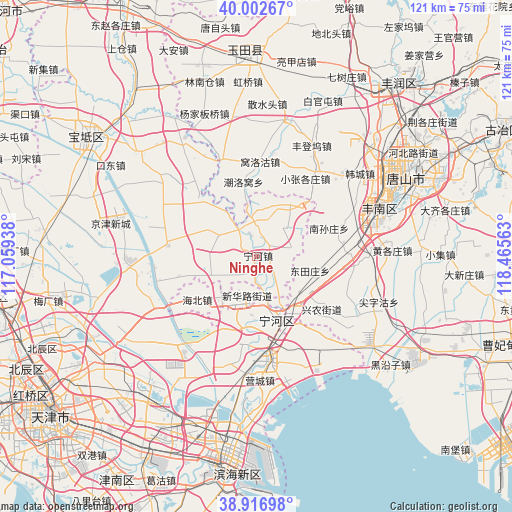
Ninghe GPS coordinates[2]
39° 27' 42.984" North, 117° 45' 45" East
| Map corner | latitude | longitude |
|---|---|---|
| Upper-left | 40.00267°, | 117.05938° |
| Center: | 39.46194°, | 117.7625° |
| Lower-right: | 38.91698°, | 118.46563° |
| Map W x H: | 120.7×120.7 km | = 75×75mi |
| max Lat: | 53.31946° ⇑15.5% North |
| Ninghe: | 39.46194° |
| min Lat: | ⇓84.5% South 18.22056° |
| min Long | Ninghe | max Long |
| 75.07348° | 117.7625° | 134.28917° |
| W 69.7%⇐ | ⇒30.3% E |
Elevation
Elevation of Ninghe is 2 m = 7 ft, and this is 482.8 m = 1584 ft below average elevation for this country.
| Max E: |
5622 m = 18445 ft | 99.4% |
| Avg. | 484.8 m = 1591 ft | |
| Ninghe | 2 m = 7 ft | |
Min E: |
-3 m = -10 ft | 0.6% |
See also: China elevation on elevation.city.
Geographical zone
Ninghe is located in North temperate zone (between Tropic of Cancer and the Arctic Circle). Distance of this Northern Tropic circle is 1781.8 km =1107.2 mi to South.| Distance of | km | miles | from Ninghe |
|---|---|---|---|
| North Pole | 5619.3 | 3491.7 | to North |
| Arctic Circle | 3013.4 | 1872.4 | to North |
| Tropic Cancer | 1781.8 | 1107.2 | to South |
| Equator | 4387.8 | 2726.5 | to South |


Nearby cities:
15 places around Ninghe: (largest is in red/bold)
• Bamencheng
18.6 km =11.6 mi,  313°
313°
• Dadengzhuang
12.7 km =7.9 mi,  282°
282°
• Daxinzhuang
8 km =5 mi, 305°
• Dongjituo
16.8 km =10.4 mi,  254°
254°
• Duli
17.3 km =10.7 mi,  201°
201°
• Fengtai
10.7 km =6.6 mi,  353°
353°
• Gaojingzhuang
12.5 km =7.8 mi, 245°
• Jiangwakou
8.5 km =5.3 mi,  322°
322°
• Lianzhuang
5.8 km =3.6 mi,  185°
185°
• Miaozhuang
5.7 km =3.5 mi,  140°
140°
• Nanmaizhu
4.8 km =3 mi,  341°
341°
• Penguanzhuang
5 km =3.1 mi,  60°
60°
• Qiaogu
16.9 km =10.5 mi, 191°
• Renfengzhuang
18.8 km =11.7 mi,  207°
207°
• Zhaobenzhuang
11.2 km =7 mi,  271°
271°
Sources, notices
• [Note1] Compared only with cities in China existing in our database
• [Src1] Map data: © OpenStreetMap contributors (CC-BY-SA)
• [Src2] Other city data from geonames.org with taken over terms of usage.
• [Src3] Geographical zone / Annual Mean Temperature by Robert A. Rohde @ Wikipedia
