Jiangwakou geodata
Jiangwakou (Tianjin) is a populated place; located in China in Asia/Shanghai (GMT+8) time zone. With population of 2,018 people, there are 1028 cities with bigger population in this country. Compared to other cities in China, 84.8% of cities are located further ↓South; 69.5% of cities are located further ←West and 99.9% of cities have higher elevation than Jiangwakou. Note1


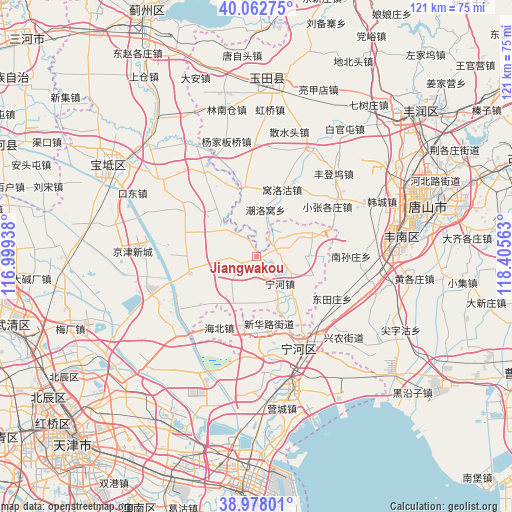
Jiangwakou GPS coordinates[2]
39° 31' 21" North, 117° 42' 9" East
| Map corner | latitude | longitude |
|---|---|---|
| Upper-left | 40.06275°, | 116.99938° |
| Center: | 39.5225°, | 117.7025° |
| Lower-right: | 38.97801°, | 118.40563° |
| Map W x H: | 120.6×120.6 km | = 74.9×74.9mi |
| max Lat: | 53.31946° ⇑15.2% North |
| Jiangwakou: | 39.5225° |
| min Lat: | ⇓84.8% South 18.22056° |
| min Long | Jiangwakou | max Long |
| 75.07348° | 117.7025° | 134.28917° |
| W 69.5%⇐ | ⇒30.5% E |
Elevation
Elevation of Jiangwakou is 0 m = 0 ft, and this is 484.8 m = 1591 ft below average elevation for this country.
| Max E: |
5622 m = 18445 ft | 99.9% |
| Avg. | 484.8 m = 1591 ft | |
| Jiangwakou | 0 m = 0 ft | |
Min E: |
-3 m = -10 ft | 0.1% |
See also: China elevation on elevation.city.
Geographical zone
Jiangwakou is located in North temperate zone (between Tropic of Cancer and the Arctic Circle). Distance of this Northern Tropic circle is 1788.6 km =1111.4 mi to South.| Distance of | km | miles | from Jiangwakou |
|---|---|---|---|
| North Pole | 5612.6 | 3487.5 | to North |
| Arctic Circle | 3006.7 | 1868.3 | to North |
| Tropic Cancer | 1788.6 | 1111.4 | to South |
| Equator | 4394.5 | 2730.6 | to South |


Nearby cities:
15 places around Jiangwakou: (largest is in red/bold)
• Bamencheng
10.4 km =6.5 mi,  306°
306°
• Beilizigu
20.7 km =12.9 mi,  260°
260°
• Dadengzhuang
8.3 km =5.2 mi,  241°
241°
• Daxinzhuang
2.5 km =1.6 mi,  213°
213°
• Dongjituo
15.7 km =9.8 mi,  224°
224°
• Fengtai
5.6 km =3.5 mi,  45°
45°
• Gaojingzhuang
13.4 km =8.3 mi, 207°
• Huangzhuang
16.8 km =10.4 mi,  254°
254°
• Lianzhuang
13.3 km =8.3 mi,  159°
159°
• Lintingkou
21.1 km =13.1 mi,  304°
304°
• Miaozhuang
14.2 km =8.8 mi,  141°
141°
• Nanmaizhu
4.2 km =2.6 mi,  121°
121°
• Ninghe
8.5 km =5.3 mi, 142°
• Penguanzhuang
10.4 km =6.5 mi,  114°
114°
• Zhaobenzhuang
8.9 km =5.5 mi, 222°
Sources, notices
• [Note1] Compared only with cities in China existing in our database
• [Src1] Map data: © OpenStreetMap contributors (CC-BY-SA)
• [Src2] Other city data from geonames.org with taken over terms of usage.
• [Src3] Geographical zone / Annual Mean Temperature by Robert A. Rohde @ Wikipedia
