Ganjun geodata
Ganjun (Gansu) is a seat of a fourth-order administrative division; located in China in Asia/Shanghai (GMT+8) time zone. In our database, there are 1268 cities with bigger population. Compared to other cities in China, 82.6% of cities are located further ↓South; 94.4% of cities are located further →East and 92.1% of cities have lower elevation than Ganjun. Note1


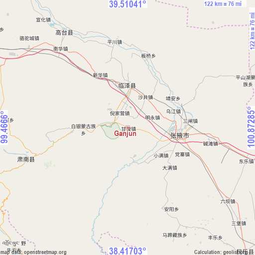
Ganjun GPS coordinates[2]
38° 57' 56.988" North, 100° 10' 10.992" East
| Map corner | latitude | longitude |
|---|---|---|
| Upper-left | 39.51041°, | 99.4666° |
| Center: | 38.96583°, | 100.16972° |
| Lower-right: | 38.41703°, | 100.87285° |
| Map W x H: | 121.6×121.6 km | = 75.6×75.6mi |
| max Lat: | 53.31946° ⇑17.4% North |
| Ganjun: | 38.96583° |
| min Lat: | ⇓82.6% South 18.22056° |
| min Long | Ganjun | max Long |
| 75.07348° | 100.16972° | 134.28917° |
| W 5.6%⇐ | ⇒94.4% E |
Elevation
Elevation of Ganjun is 1587 m = 5207 ft, and this is 1102.2 m = 3616 ft above average elevation for this country.
| Max E: |
5622 m = 18445 ft | 7.9% |
| Ganjun | 1587 m 5207 ft | |
| Avg. | 484.8 m = 1591 ft | |
Min E: |
-3 m = -10 ft | 92.1% |
See also: China elevation on elevation.city.
Geographical zone
Ganjun is located in North temperate zone (between Tropic of Cancer and the Arctic Circle). Distance of this Northern Tropic circle is 1726.7 km =1072.9 mi to South.| Distance of | km | miles | from Ganjun |
|---|---|---|---|
| North Pole | 5674.5 | 3526 | to North |
| Arctic Circle | 3068.6 | 1906.7 | to North |
| Tropic Cancer | 1726.7 | 1072.9 | to South |
| Equator | 4332.6 | 2692.2 | to South |


Nearby cities:
15 places around Ganjun: (largest is in red/bold)
• Baiyin
24.9 km =15.5 mi,  257°
257°
• Banqiao
38.7 km =24 mi,  18°
18°
• Daman
26.4 km =16.4 mi,  126°
126°
• Huazhai
41.6 km =25.8 mi,  156°
156°
• Jing’an
25.9 km =16.1 mi,  53°
53°
• Longqu
18.6 km =11.6 mi,  144°
144°
• Nanjie
26.2 km =16.3 mi,  92°
92°
• Qinglong
42 km =26.1 mi, 257°
• Sanzha
28.2 km =17.5 mi,  81°
81°
• Shahe
19.6 km =12.2 mi,  2°
2°
• Shajing
17.1 km =10.6 mi,  29°
29°
• Wujiang
26.3 km =16.3 mi, 77°
• Xinhua
29.9 km =18.6 mi,  330°
330°
• Xishui
36.6 km =22.7 mi,  178°
178°
• Zhangye
24.6 km =15.3 mi,  98°
98°
Sources, notices
• [Note1] Compared only with cities in China existing in our database
• [Src1] Map data: © OpenStreetMap contributors (CC-BY-SA)
• [Src2] Other city data from geonames.org with taken over terms of usage.
• [Src3] Geographical zone / Annual Mean Temperature by Robert A. Rohde @ Wikipedia
