Xishui geodata
Xishui (Gansu) is a seat of a fourth-order administrative division; located in China in Asia/Shanghai (GMT+8) time zone. In our database, there are 1268 cities with bigger population. Compared to other cities in China, 82% of cities are located further ↓South; 94.4% of cities are located further →East and 96.9% of cities have lower elevation than Xishui. Note1


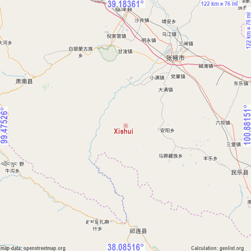
Xishui GPS coordinates[2]
38° 38' 11.364" North, 100° 10' 42.168" East
| Map corner | latitude | longitude |
|---|---|---|
| Upper-left | 39.18361°, | 99.47526° |
| Center: | 38.63649°, | 100.17838° |
| Lower-right: | 38.08516°, | 100.88151° |
| Map W x H: | 122.1×122.1 km | = 75.9×75.9mi |
| max Lat: | 53.31946° ⇑18% North |
| Xishui: | 38.63649° |
| min Lat: | ⇓82% South 18.22056° |
| min Long | Xishui | max Long |
| 75.07348° | 100.17838° | 134.28917° |
| W 5.6%⇐ | ⇒94.4% E |
Elevation
Elevation of Xishui is 2976 m = 9764 ft, and this is 2491.2 m = 8173 ft above average elevation for this country.
| Max E: |
5622 m = 18445 ft | 3.1% |
| Xishui | 2976 m 9764 ft | |
| Avg. | 484.8 m = 1591 ft | |
Min E: |
-3 m = -10 ft | 96.9% |
See also: China elevation on elevation.city.
Geographical zone
Xishui is located in North temperate zone (between Tropic of Cancer and the Arctic Circle). Distance of this Northern Tropic circle is 1690.1 km =1050.2 mi to South.| Distance of | km | miles | from Xishui |
|---|---|---|---|
| North Pole | 5711.1 | 3548.7 | to North |
| Arctic Circle | 3105.2 | 1929.5 | to North |
| Tropic Cancer | 1690.1 | 1050.2 | to South |
| Equator | 4296 | 2669.4 | to South |


Nearby cities:
15 places around Xishui: (largest is in red/bold)
• Baiyin
40.2 km =25 mi,  321°
321°
• Daman
29.3 km =18.2 mi,  44°
44°
• Ganjun
36.6 km =22.7 mi,  358°
358°
• Huazhai
15.7 km =9.8 mi,  95°
95°
• Liuba
46.9 km =29.1 mi,  88°
88°
• Longqu
23.7 km =14.7 mi,  25°
25°
• Nangu
26.8 km =16.7 mi,  113°
113°
• Nanjie
43.6 km =27.1 mi, 35°
• Qinglong
49.9 km =31 mi,  303°
303°
• Sanzha
49 km =30.4 mi, 33°
• Shunhua
50.2 km =31.2 mi, 111°
• Wujiang
49.1 km =30.5 mi, 30°
• Xintian
34.1 km =21.2 mi, 110°
• Zamashi
50.2 km =31.2 mi,  196°
196°
• Zhangye
40.7 km =25.3 mi, 35°
Sources, notices
• [Note1] Compared only with cities in China existing in our database
• [Src1] Map data: © OpenStreetMap contributors (CC-BY-SA)
• [Src2] Other city data from geonames.org with taken over terms of usage.
• [Src3] Geographical zone / Annual Mean Temperature by Robert A. Rohde @ Wikipedia
