Xinhua geodata
Xinhua (Gansu) is a seat of a fourth-order administrative division; located in China in Asia/Shanghai (GMT+8) time zone. In our database, there are 1268 cities with bigger population. Compared to other cities in China, 83.7% of cities are located further ↓South; 94.5% of cities are located further →East and 90.8% of cities have lower elevation than Xinhua. Note1


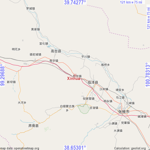
Xinhua GPS coordinates[2]
39° 12' 0" North, 100° 0' 0" East
| Map corner | latitude | longitude |
|---|---|---|
| Upper-left | 39.74277°, | 99.29688° |
| Center: | 39.2°, | 100° |
| Lower-right: | 38.65301°, | 100.70313° |
| Map W x H: | 121.2×121.2 km | = 75.3×75.3mi |
| max Lat: | 53.31946° ⇑16.3% North |
| Xinhua: | 39.2° |
| min Lat: | ⇓83.7% South 18.22056° |
| min Long | Xinhua | max Long |
| 75.07348° | 100° | 134.28917° |
| W 5.5%⇐ | ⇒94.5% E |
Elevation
Elevation of Xinhua is 1430 m = 4692 ft, and this is 945.2 m = 3101 ft above average elevation for this country.
| Max E: |
5622 m = 18445 ft | 9.2% |
| Xinhua | 1430 m 4692 ft | |
| Avg. | 484.8 m = 1591 ft | |
Min E: |
-3 m = -10 ft | 90.8% |
See also: China elevation on elevation.city.
Geographical zone
Xinhua is located in North temperate zone (between Tropic of Cancer and the Arctic Circle). Distance of this Northern Tropic circle is 1752.7 km =1089.1 mi to South.| Distance of | km | miles | from Xinhua |
|---|---|---|---|
| North Pole | 5648.4 | 3509.8 | to North |
| Arctic Circle | 3042.5 | 1890.5 | to North |
| Tropic Cancer | 1752.7 | 1089.1 | to South |
| Equator | 4358.6 | 2708.3 | to South |


Nearby cities:
15 places around Xinhua: (largest is in red/bold)
• Baiyin
32.8 km =20.4 mi,  197°
197°
• Banqiao
29.1 km =18.1 mi,  68°
68°
• Ganjun
29.9 km =18.6 mi,  150°
150°
• Gaotai Chengguanzhen
23.5 km =14.6 mi,  313°
313°
• Heiquan
48.2 km =30 mi,  316°
316°
• Jing’an
37 km =23 mi,  106°
106°
• Liaoquan
16.9 km =10.5 mi,  9°
9°
• Longqu
48.4 km =30.1 mi, 148°
• Nanhua
22.7 km =14.1 mi,  304°
304°
• Qinglong
44.1 km =27.4 mi,  216°
216°
• Sanzha
47.9 km =29.8 mi,  117°
117°
• Shahe
16.7 km =10.4 mi, 112°
• Shajing
25.5 km =15.8 mi, 115°
• Wujiang
45.1 km =28 mi, 116°
• Zhangye
48.9 km =30.4 mi,  127°
127°
Sources, notices
• [Note1] Compared only with cities in China existing in our database
• [Src1] Map data: © OpenStreetMap contributors (CC-BY-SA)
• [Src2] Other city data from geonames.org with taken over terms of usage.
• [Src3] Geographical zone / Annual Mean Temperature by Robert A. Rohde @ Wikipedia
