Gangtou geodata
Gangtou (Fujian) is a seat of a fourth-order administrative division; located in China in Asia/Shanghai (GMT+8) time zone. In our database, there are 1268 cities with bigger population. Compared to other cities in China, 84% of cities are located further ↑North; 78.7% of cities are located further ←West and 81.2% of cities have higher elevation than Gangtou. Note1


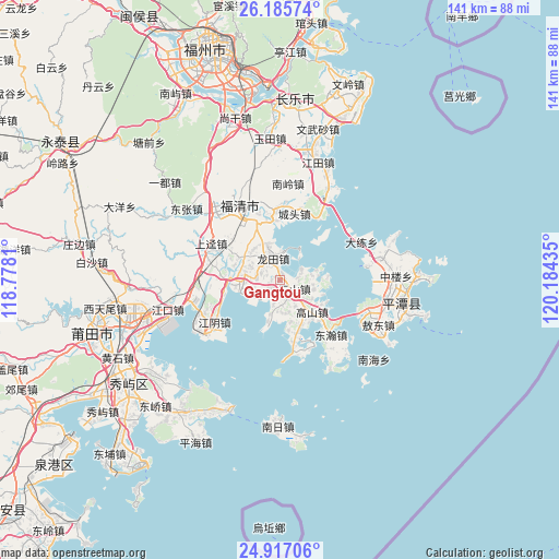
Gangtou GPS coordinates[2]
25° 33' 11.088" North, 119° 28' 52.392" East
| Map corner | latitude | longitude |
|---|---|---|
| Upper-left | 26.18574°, | 118.7781° |
| Center: | 25.55308°, | 119.48122° |
| Lower-right: | 24.91706°, | 120.18435° |
| Map W x H: | 141.1×141.1 km | = 87.7×87.7mi |
| max Lat: | 53.31946° ⇑84% North |
| Gangtou: | 25.55308° |
| min Lat: | ⇓16% South 18.22056° |
| min Long | Gangtou | max Long |
| 75.07348° | 119.48122° | 134.28917° |
| W 78.7%⇐ | ⇒21.3% E |
Elevation
Elevation of Gangtou is 24 m = 79 ft, and this is 460.8 m = 1512 ft below average elevation for this country.
| Max E: |
5622 m = 18445 ft | 81.2% |
| Avg. | 484.8 m = 1591 ft | |
| Gangtou | 24 m = 79 ft | |
Min E: |
-3 m = -10 ft | 18.8% |
See also: China elevation on elevation.city.
Geographical zone
Gangtou is located in North temperate zone (between Tropic of Cancer and the Arctic Circle). Distance of this Northern Tropic circle is 235.3 km =146.2 mi to South.| Distance of | km | miles | from Gangtou |
|---|---|---|---|
| North Pole | 7165.8 | 4452.6 | to North |
| Arctic Circle | 4559.9 | 2833.4 | to North |
| Tropic Cancer | 235.3 | 146.2 | to South |
| Equator | 2841.2 | 1765.4 | to South |


Nearby cities:
15 places around Gangtou: (largest is in red/bold)
• Chengtou
16.8 km =10.4 mi,  11°
11°
• Dalian
22.7 km =14.1 mi,  64°
64°
• Donghan
18.4 km =11.4 mi,  137°
137°
• Fuqing
21.7 km =13.5 mi,  331°
331°
• Gaoshan
11.9 km =7.4 mi, 139°
• Haikou
15.8 km =9.8 mi,  352°
352°
• Jiangjing
6.2 km =3.9 mi,  271°
271°
• Jiangyin
19.5 km =12.1 mi,  238°
238°
• Longtian
7 km =4.3 mi,  337°
337°
• Sanshan
4.1 km =2.5 mi,  119°
119°
• Shangjing
20 km =12.4 mi,  298°
298°
• Shapu
13.8 km =8.6 mi,  161°
161°
• Yangxia
23.4 km =14.5 mi, 334°
• Yutou
15.2 km =9.4 mi,  45°
45°
• Yuxi
19.8 km =12.3 mi,  286°
286°
Sources, notices
• [Note1] Compared only with cities in China existing in our database
• [Src1] Map data: © OpenStreetMap contributors (CC-BY-SA)
• [Src2] Other city data from geonames.org with taken over terms of usage.
• [Src3] Geographical zone / Annual Mean Temperature by Robert A. Rohde @ Wikipedia
