Donghan geodata
Donghan (Fujian) is a seat of a fourth-order administrative division; located in China in Asia/Shanghai (GMT+8) time zone. In our database, there are 1268 cities with bigger population. Compared to other cities in China, 84.5% of cities are located further ↑North; 79.5% of cities are located further ←West and 86.2% of cities have higher elevation than Donghan. Note1


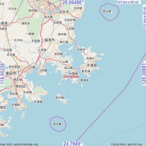
Donghan GPS coordinates[2]
25° 25' 53.58" North, 119° 36' 20.448" East
| Map corner | latitude | longitude |
|---|---|---|
| Upper-left | 26.06486°, | 118.90256° |
| Center: | 25.43155°, | 119.60568° |
| Lower-right: | 24.7949°, | 120.30881° |
| Map W x H: | 141.2×141.2 km | = 87.7×87.7mi |
| max Lat: | 53.31946° ⇑84.5% North |
| Donghan: | 25.43155° |
| min Lat: | ⇓15.5% South 18.22056° |
| min Long | Donghan | max Long |
| 75.07348° | 119.60568° | 134.28917° |
| W 79.5%⇐ | ⇒20.5% E |
Elevation
Elevation of Donghan is 14 m = 46 ft, and this is 470.8 m = 1545 ft below average elevation for this country.
| Max E: |
5622 m = 18445 ft | 86.2% |
| Avg. | 484.8 m = 1591 ft | |
| Donghan | 14 m = 46 ft | |
Min E: |
-3 m = -10 ft | 13.8% |
See also: China elevation on elevation.city.
Geographical zone
Donghan is located in North temperate zone (between Tropic of Cancer and the Arctic Circle). Distance of this Northern Tropic circle is 221.8 km =137.8 mi to South.| Distance of | km | miles | from Donghan |
|---|---|---|---|
| North Pole | 7179.3 | 4461 | to North |
| Arctic Circle | 4573.5 | 2841.8 | to North |
| Tropic Cancer | 221.8 | 137.8 | to South |
| Equator | 2827.7 | 1757.1 | to South |


Nearby cities:
15 places around Donghan: (largest is in red/bold)
• Aodong
12.6 km =7.8 mi,  79°
79°
• Aoqian
24.2 km =15 mi, 81°
• Beicuo
14.2 km =8.8 mi,  67°
67°
• Gangtou
18.4 km =11.4 mi,  317°
317°
• Gaoshan
6.6 km =4.1 mi,  312°
312°
• Jiangjing
23.1 km =14.4 mi, 306°
• Lancheng
19.4 km =12.1 mi,  62°
62°
• Luyang
22.9 km =14.2 mi,  41°
41°
• Nanhai
12.9 km =8 mi,  118°
118°
• Sanshan
14.5 km =9 mi, 322°
• Shapu
8.2 km =5.1 mi,  273°
273°
• Su’ao
22.9 km =14.2 mi,  26°
26°
• Tancheng
21.9 km =13.6 mi, 67°
• Yutou
24.3 km =15.1 mi,  356°
356°
• Zhonglou
22.2 km =13.8 mi,  48°
48°
Sources, notices
• [Note1] Compared only with cities in China existing in our database
• [Src1] Map data: © OpenStreetMap contributors (CC-BY-SA)
• [Src2] Other city data from geonames.org with taken over terms of usage.
• [Src3] Geographical zone / Annual Mean Temperature by Robert A. Rohde @ Wikipedia
