Chengtou geodata
Chengtou (Fujian) is a seat of a fourth-order administrative division; located in China in Asia/Shanghai (GMT+8) time zone. In our database, there are 1268 cities with bigger population. Compared to other cities in China, 83.5% of cities are located further ↑North; 78.9% of cities are located further ←West and 84.9% of cities have higher elevation than Chengtou. Note1


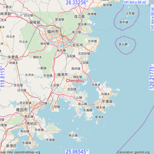
Chengtou GPS coordinates[2]
25° 42' 2.484" North, 119° 30' 52.632" East
| Map corner | latitude | longitude |
|---|---|---|
| Upper-left | 26.33256°, | 118.8115° |
| Center: | 25.70069°, | 119.51462° |
| Lower-right: | 25.06545°, | 120.21775° |
| Map W x H: | 140.9×140.9 km | = 87.6×87.6mi |
| max Lat: | 53.31946° ⇑83.5% North |
| Chengtou: | 25.70069° |
| min Lat: | ⇓16.5% South 18.22056° |
| min Long | Chengtou | max Long |
| 75.07348° | 119.51462° | 134.28917° |
| W 78.9%⇐ | ⇒21.1% E |
Elevation
Elevation of Chengtou is 16 m = 52 ft, and this is 468.8 m = 1538 ft below average elevation for this country.
| Max E: |
5622 m = 18445 ft | 84.9% |
| Avg. | 484.8 m = 1591 ft | |
| Chengtou | 16 m = 52 ft | |
Min E: |
-3 m = -10 ft | 15.1% |
See also: China elevation on elevation.city.
Geographical zone
Chengtou is located in North temperate zone (between Tropic of Cancer and the Arctic Circle). Distance of this Northern Tropic circle is 251.7 km =156.4 mi to South.| Distance of | km | miles | from Chengtou |
|---|---|---|---|
| North Pole | 7149.4 | 4442.4 | to North |
| Arctic Circle | 4543.5 | 2823.2 | to North |
| Tropic Cancer | 251.7 | 156.4 | to South |
| Equator | 2857.6 | 1775.6 | to South |


Nearby cities:
15 places around Chengtou: (largest is in red/bold)
• Dalian
18.4 km =11.4 mi,  111°
111°
• Fuqing
13.8 km =8.6 mi,  281°
281°
• Gangtou
16.8 km =10.4 mi,  191°
191°
• Haikou
5.6 km =3.5 mi,  262°
262°
• Honglu
20.1 km =12.5 mi,  271°
271°
• Jiangjing
18.8 km =11.7 mi,  210°
210°
• Jiangtian
14.5 km =9 mi,  24°
24°
• Longtian
11.6 km =7.2 mi, 211°
• Luolian
17.9 km =11.1 mi,  345°
345°
• Nanling
8 km =5 mi, 346°
• Sanshan
18.5 km =11.5 mi,  179°
179°
• Songxia
10.6 km =6.6 mi,  48°
48°
• Yangxia
14.3 km =8.9 mi,  288°
288°
• Yinxi
16 km =9.9 mi, 282°
• Yutou
9.4 km =5.8 mi,  127°
127°
Sources, notices
• [Note1] Compared only with cities in China existing in our database
• [Src1] Map data: © OpenStreetMap contributors (CC-BY-SA)
• [Src2] Other city data from geonames.org with taken over terms of usage.
• [Src3] Geographical zone / Annual Mean Temperature by Robert A. Rohde @ Wikipedia
