Gangkou geodata
Gangkou (Jiangxi) is a seat of a fourth-order administrative division; located in China in Asia/Shanghai (GMT+8) time zone. In our database, there are 1268 cities with bigger population. Compared to other cities in China, 67.6% of cities are located further ↑North; 50.3% of cities are located further ←West and 57.7% of cities have lower elevation than Gangkou. Note1


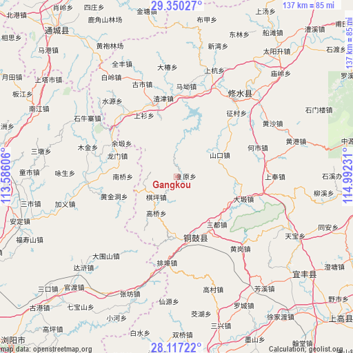
Gangkou GPS coordinates[2]
28° 44' 8.016" North, 114° 17' 21.048" East
| Map corner | latitude | longitude |
|---|---|---|
| Upper-left | 29.35027°, | 113.58606° |
| Center: | 28.73556°, | 114.28918° |
| Lower-right: | 28.11722°, | 114.99231° |
| Map W x H: | 137.1×137.1 km | = 85.2×85.2mi |
| max Lat: | 53.31946° ⇑67.6% North |
| Gangkou: | 28.73556° |
| min Lat: | ⇓32.4% South 18.22056° |
| min Long | Gangkou | max Long |
| 75.07348° | 114.28918° | 134.28917° |
| W 50.3%⇐ | ⇒49.7% E |
Elevation
Elevation of Gangkou is 233 m = 764 ft, and this is 251.8 m = 826 ft below average elevation for this country.
| Max E: |
5622 m = 18445 ft | 42.3% |
| Avg. | 484.8 m = 1591 ft | |
| Gangkou | 233 m = 764 ft | |
Min E: |
-3 m = -10 ft | 57.7% |
See also: China elevation on elevation.city.
Geographical zone
Gangkou is located in North temperate zone (between Tropic of Cancer and the Arctic Circle). Distance of this Northern Tropic circle is 589.2 km =366.1 mi to South.| Distance of | km | miles | from Gangkou |
|---|---|---|---|
| North Pole | 6812 | 4232.8 | to North |
| Arctic Circle | 4206.1 | 2613.5 | to North |
| Tropic Cancer | 589.2 | 366.1 | to South |
| Equator | 3195.1 | 1985.3 | to South |


Nearby cities:
15 places around Gangkou: (largest is in red/bold)
• Daduan
27.2 km =16.9 mi,  108°
108°
• Donggang
23.2 km =14.4 mi,  344°
344°
• Fuyuan
3.6 km =2.2 mi,  84°
84°
• Gaoqiao
16.3 km =10.1 mi,  209°
209°
• Huangjindong
24.7 km =15.3 mi,  247°
247°
• Longmen
24.4 km =15.2 mi,  289°
289°
• Manjiang
14.9 km =9.3 mi,  49°
49°
• Nanqiao
21.2 km =13.2 mi,  270°
270°
• Qiping
11.4 km =7.1 mi,  226°
226°
• Sandu
24 km =14.9 mi,  140°
140°
• Shangshan
27 km =16.8 mi,  332°
332°
• Shankou
18.9 km =11.7 mi,  63°
63°
• Wenquan
22.8 km =14.2 mi,  165°
165°
• Yongning
24.6 km =15.3 mi,  162°
162°
• Yuduan
25.2 km =15.7 mi,  301°
301°
Sources, notices
• [Note1] Compared only with cities in China existing in our database
• [Src1] Map data: © OpenStreetMap contributors (CC-BY-SA)
• [Src2] Other city data from geonames.org with taken over terms of usage.
• [Src3] Geographical zone / Annual Mean Temperature by Robert A. Rohde @ Wikipedia
