Manjiang geodata
Manjiang (Jiangxi) is a seat of a fourth-order administrative division; located in China in Asia/Shanghai (GMT+8) time zone. In our database, there are 1268 cities with bigger population. Compared to other cities in China, 67% of cities are located further ↑North; 51% of cities are located further ←West and 53.4% of cities have higher elevation than Manjiang. Note1


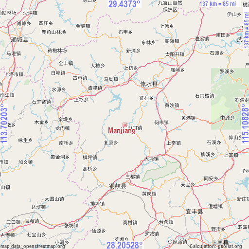
Manjiang GPS coordinates[2]
28° 49' 23.196" North, 114° 24' 18.54" East
| Map corner | latitude | longitude |
|---|---|---|
| Upper-left | 29.4373°, | 113.70203° |
| Center: | 28.82311°, | 114.40515° |
| Lower-right: | 28.20528°, | 115.10828° |
| Map W x H: | 137×137 km | = 85.1×85.1mi |
| max Lat: | 53.31946° ⇑67% North |
| Manjiang: | 28.82311° |
| min Lat: | ⇓33% South 18.22056° |
| min Long | Manjiang | max Long |
| 75.07348° | 114.40515° | 134.28917° |
| W 51%⇐ | ⇒49% E |
Elevation
Elevation of Manjiang is 141 m = 463 ft, and this is 343.8 m = 1128 ft below average elevation for this country.
| Max E: |
5622 m = 18445 ft | 53.4% |
| Avg. | 484.8 m = 1591 ft | |
| Manjiang | 141 m = 463 ft | |
Min E: |
-3 m = -10 ft | 46.6% |
See also: China elevation on elevation.city.
Geographical zone
Manjiang is located in North temperate zone (between Tropic of Cancer and the Arctic Circle). Distance of this Northern Tropic circle is 598.9 km =372.1 mi to South.| Distance of | km | miles | from Manjiang |
|---|---|---|---|
| North Pole | 6802.2 | 4226.7 | to North |
| Arctic Circle | 4196.3 | 2607.5 | to North |
| Tropic Cancer | 598.9 | 372.1 | to South |
| Equator | 3204.8 | 1991.4 | to South |


Nearby cities:
15 places around Manjiang: (largest is in red/bold)
• Chengfang
18 km =11.2 mi,  342°
342°
• Daduan
23.4 km =14.5 mi,  141°
141°
• Daixi
27.2 km =16.9 mi,  127°
127°
• Donggang
21.5 km =13.4 mi,  305°
305°
• Fuyuan
12.2 km =7.6 mi,  219°
219°
• Gangkou
14.9 km =9.3 mi,  229°
229°
• Hangkou
25.2 km =15.7 mi,  8°
8°
• Heshi
20 km =12.4 mi,  84°
84°
• Ma’ao
26.9 km =16.7 mi, 343°
• Qiping
26.3 km =16.3 mi, 228°
• Shangshan
27.8 km =17.3 mi,  300°
300°
• Shankou
5.8 km =3.6 mi,  104°
104°
• Zhajin
26.5 km =16.5 mi,  321°
321°
• Zhengcun
19 km =11.8 mi,  39°
39°
• Zhuping
22 km =13.7 mi,  17°
17°
Sources, notices
• [Note1] Compared only with cities in China existing in our database
• [Src1] Map data: © OpenStreetMap contributors (CC-BY-SA)
• [Src2] Other city data from geonames.org with taken over terms of usage.
• [Src3] Geographical zone / Annual Mean Temperature by Robert A. Rohde @ Wikipedia
