Fuyuan geodata
Fuyuan (Jiangxi) is a seat of a fourth-order administrative division; located in China in Asia/Shanghai (GMT+8) time zone. In our database, there are 1268 cities with bigger population. Compared to other cities in China, 67.6% of cities are located further ↑North; 50.5% of cities are located further ←West and 57.4% of cities have lower elevation than Fuyuan. Note1


Fuyuan GPS coordinates[2]
28° 44' 18.492" North, 114° 19' 34.284" East
| Map corner | latitude | longitude |
|---|---|---|
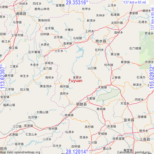
| Upper-left | 29.35316°, | 113.62307° |
| Center: | 28.73847°, | 114.32619° |
| Lower-right: | 28.12014°, | 115.02932° |
| Map W x H: | 137.1×137.1 km | = 85.2×85.2mi |
| max Lat: | 53.31946° ⇑67.6% North |
| Fuyuan: | 28.73847° |
| min Lat: | ⇓32.4% South 18.22056° |
| min Long | Fuyuan | max Long |
| 75.07348° | 114.32619° | 134.28917° |
| W 50.5%⇐ | ⇒49.5% E |
Elevation
Elevation of Fuyuan is 229 m = 751 ft, and this is 255.8 m = 839 ft below average elevation for this country.
| Max E: |
5622 m = 18445 ft | 42.6% |
| Avg. | 484.8 m = 1591 ft | |
| Fuyuan | 229 m = 751 ft | |
Min E: |
-3 m = -10 ft | 57.4% |
See also: China elevation on elevation.city.
Geographical zone
Fuyuan is located in North temperate zone (between Tropic of Cancer and the Arctic Circle). Distance of this Northern Tropic circle is 589.5 km =366.3 mi to South.| Distance of | km | miles | from Fuyuan |
|---|---|---|---|
| North Pole | 6811.6 | 4232.5 | to North |
| Arctic Circle | 4205.8 | 2613.4 | to North |
| Tropic Cancer | 589.5 | 366.3 | to South |
| Equator | 3195.4 | 1985.5 | to South |


Nearby cities:
15 places around Fuyuan: (largest is in red/bold)
• Chengfang
26.6 km =16.5 mi,  4°
4°
• Daduan
24 km =14.9 mi,  111°
111°
• Donggang
24.1 km =15 mi,  336°
336°
• Gangkou
3.6 km =2.2 mi,  264°
264°
• Gaoqiao
18.6 km =11.6 mi,  218°
218°
• Huangjindong
28.2 km =17.5 mi,  249°
249°
• Longmen
27.8 km =17.3 mi,  286°
286°
• Manjiang
12.2 km =7.6 mi,  39°
39°
• Nanqiao
24.8 km =15.4 mi,  269°
269°
• Qiping
14.4 km =8.9 mi,  235°
235°
• Sandu
22.1 km =13.7 mi,  147°
147°
• Shankou
15.5 km =9.6 mi,  59°
59°
• Wenquan
22.5 km =14 mi,  174°
174°
• Yongning
24.1 km =15 mi, 170°
• Yuduan
28.2 km =17.5 mi,  297°
297°
Sources, notices
• [Note1] Compared only with cities in China existing in our database
• [Src1] Map data: © OpenStreetMap contributors (CC-BY-SA)
• [Src2] Other city data from geonames.org with taken over terms of usage.
• [Src3] Geographical zone / Annual Mean Temperature by Robert A. Rohde @ Wikipedia
