Fuzhou geodata
Fuzhou (Fujian) is a seat of a first-order administrative division; located in China in Asia/Shanghai (GMT+8) time zone. With population of 1,179,720 people, there are 57 cities with bigger population in this country. Compared to other cities in China, 82.1% of cities are located further ↑North; 77.7% of cities are located further ←West and 86.2% of cities have higher elevation than Fuzhou. Note1


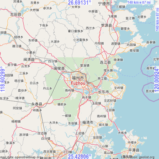
Fuzhou GPS coordinates[2]
26° 3' 41.004" North, 119° 18' 21.996" East
| Map corner | latitude | longitude |
|---|---|---|
| Upper-left | 26.69131°, | 118.60299° |
| Center: | 26.06139°, | 119.30611° |
| Lower-right: | 25.42806°, | 120.00924° |
| Map W x H: | 140.5×140.5 km | = 87.3×87.3mi |
| max Lat: | 53.31946° ⇑82.1% North |
| Fuzhou: | 26.06139° |
| min Lat: | ⇓17.9% South 18.22056° |
| min Long | Fuzhou | max Long |
| 75.07348° | 119.30611° | 134.28917° |
| W 77.7%⇐ | ⇒22.3% E |
Elevation
Elevation of Fuzhou is 14 m = 46 ft, and this is 470.8 m = 1545 ft below average elevation for this country.
| Max E: |
5622 m = 18445 ft | 86.2% |
| Avg. | 484.8 m = 1591 ft | |
| Fuzhou | 14 m = 46 ft | |
Min E: |
-3 m = -10 ft | 13.8% |
See also: Fuzhou elevation on elevation.city.
Geographical zone
Fuzhou is located in North temperate zone (between Tropic of Cancer and the Arctic Circle). Distance of this Northern Tropic circle is 291.8 km =181.3 mi to South.| Distance of | km | miles | from Fuzhou |
|---|---|---|---|
| North Pole | 7109.3 | 4417.5 | to North |
| Arctic Circle | 4503.4 | 2798.3 | to North |
| Tropic Cancer | 291.8 | 181.3 | to South |
| Equator | 2897.8 | 1800.6 | to South |


Nearby cities:
15 places around Fuzhou: (largest is in red/bold)
• Antai
2.6 km =1.6 mi,  331°
331°
• Cangshan
2.6 km =1.6 mi,  175°
175°
• Chayuan
5.9 km =3.7 mi,  8°
8°
• Dongjie
3.2 km =2 mi,  338°
338°
• Gaishan
4.8 km =3 mi,  149°
149°
• Gudong
3.7 km =2.3 mi, 344°
• Gulou
2.9 km =1.8 mi, 343°
• Gushan
4 km =2.5 mi,  69°
69°
• Guxi
3.8 km =2.4 mi, 325°
• Hongshan
4 km =2.5 mi,  298°
298°
• Huada
4.8 km =3 mi, 336°
• Nanjie
3.3 km =2.1 mi, 330°
• Wenquan
4.3 km =2.7 mi,  356°
356°
• Wufeng
5.6 km =3.5 mi, 330°
• Yuefeng
3.7 km =2.3 mi,  20°
20°
Sources, notices
• [Note1] Compared only with cities in China existing in our database
• [Src1] Map data: © OpenStreetMap contributors (CC-BY-SA)
• [Src2] Other city data from geonames.org with taken over terms of usage.
• [Src3] Geographical zone / Annual Mean Temperature by Robert A. Rohde @ Wikipedia
