Dongjie geodata
Dongjie (Fujian) is a seat of a third-order administrative division; located in China in Asia/Shanghai (GMT+8) time zone. In our database, there are 1268 cities with bigger population. Compared to other cities in China, 82% of cities are located further ↑North; 77.5% of cities are located further ←West and 88.7% of cities have higher elevation than Dongjie. Note1


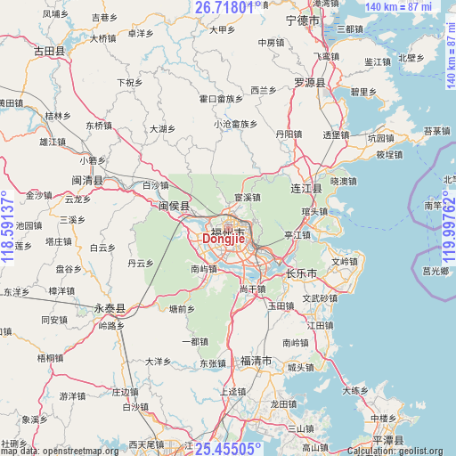
Dongjie GPS coordinates[2]
26° 5' 17.628" North, 119° 17' 40.164" East
| Map corner | latitude | longitude |
|---|---|---|
| Upper-left | 26.71801°, | 118.59137° |
| Center: | 26.08823°, | 119.29449° |
| Lower-right: | 25.45505°, | 119.99762° |
| Map W x H: | 140.4×140.4 km | = 87.2×87.2mi |
| max Lat: | 53.31946° ⇑82% North |
| Dongjie: | 26.08823° |
| min Lat: | ⇓18% South 18.22056° |
| min Long | Dongjie | max Long |
| 75.07348° | 119.29449° | 134.28917° |
| W 77.5%⇐ | ⇒22.5% E |
Elevation
Elevation of Dongjie is 11 m = 36 ft, and this is 473.8 m = 1554 ft below average elevation for this country.
| Max E: |
5622 m = 18445 ft | 88.7% |
| Avg. | 484.8 m = 1591 ft | |
| Dongjie | 11 m = 36 ft | |
Min E: |
-3 m = -10 ft | 11.3% |
See also: China elevation on elevation.city.
Geographical zone
Dongjie is located in North temperate zone (between Tropic of Cancer and the Arctic Circle). Distance of this Northern Tropic circle is 294.8 km =183.2 mi to South.| Distance of | km | miles | from Dongjie |
|---|---|---|---|
| North Pole | 7106.3 | 4415.6 | to North |
| Arctic Circle | 4500.4 | 2796.4 | to North |
| Tropic Cancer | 294.8 | 183.2 | to South |
| Equator | 2900.7 | 1802.4 | to South |


Nearby cities:
15 places around Dongjie: (largest is in red/bold)
• Antai
0.7 km =0.4 mi,  188°
188°
• Cangshan
5.7 km =3.5 mi,  166°
166°
• Chayuan
3.5 km =2.2 mi,  35°
35°
• Fuzhou
3.2 km =2 mi,  158°
158°
• Gudong
0.6 km =0.4 mi,  17°
17°
• Gulou
0.4 km =0.2 mi,  118°
118°
• Gushan
5.2 km =3.2 mi,  107°
107°
• Guxi
1 km =0.6 mi,  279°
279°
• Hongshan
2.6 km =1.6 mi,  245°
245°
• Huada
1.6 km =1 mi,  332°
332°
• Nanjie
0.5 km =0.3 mi, 253°
• Wenquan
1.6 km =1 mi,  34°
34°
• Wufeng
2.5 km =1.6 mi,  319°
319°
• Xindian
3.9 km =2.4 mi,  10°
10°
• Yuefeng
2.5 km =1.6 mi,  78°
78°
Sources, notices
• [Note1] Compared only with cities in China existing in our database
• [Src1] Map data: © OpenStreetMap contributors (CC-BY-SA)
• [Src2] Other city data from geonames.org with taken over terms of usage.
• [Src3] Geographical zone / Annual Mean Temperature by Robert A. Rohde @ Wikipedia
