Wenquan geodata
Wenquan (Fujian) is a seat of a fourth-order administrative division; located in China in Asia/Shanghai (GMT+8) time zone. In our database, there are 1268 cities with bigger population. Compared to other cities in China, 81.9% of cities are located further ↑North; 77.6% of cities are located further ←West and 82.1% of cities have higher elevation than Wenquan. Note1


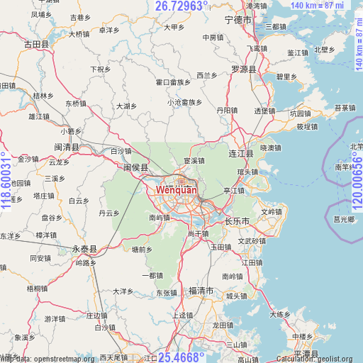
Wenquan GPS coordinates[2]
26° 5' 59.712" North, 119° 18' 12.348" East
| Map corner | latitude | longitude |
|---|---|---|
| Upper-left | 26.72963°, | 118.60031° |
| Center: | 26.09992°, | 119.30343° |
| Lower-right: | 25.4668°, | 120.00656° |
| Map W x H: | 140.4×140.4 km | = 87.2×87.2mi |
| max Lat: | 53.31946° ⇑81.9% North |
| Wenquan: | 26.09992° |
| min Lat: | ⇓18.1% South 18.22056° |
| min Long | Wenquan | max Long |
| 75.07348° | 119.30343° | 134.28917° |
| W 77.6%⇐ | ⇒22.4% E |
Elevation
Elevation of Wenquan is 22 m = 72 ft, and this is 462.8 m = 1518 ft below average elevation for this country.
| Max E: |
5622 m = 18445 ft | 82.1% |
| Avg. | 484.8 m = 1591 ft | |
| Wenquan | 22 m = 72 ft | |
Min E: |
-3 m = -10 ft | 17.9% |
See also: China elevation on elevation.city.
Geographical zone
Wenquan is located in North temperate zone (between Tropic of Cancer and the Arctic Circle). Distance of this Northern Tropic circle is 296.1 km =184 mi to South.| Distance of | km | miles | from Wenquan |
|---|---|---|---|
| North Pole | 7105 | 4414.8 | to North |
| Arctic Circle | 4499.1 | 2795.6 | to North |
| Tropic Cancer | 296.1 | 184 | to South |
| Equator | 2902 | 1803.2 | to South |


Nearby cities:
15 places around Wenquan: (largest is in red/bold)
• Antai
2.2 km =1.4 mi,  206°
206°
• Cangshan
6.8 km =4.2 mi,  176°
176°
• Chayuan
2 km =1.2 mi,  36°
36°
• Dongjie
1.6 km =1 mi, 214°
• Fuzhou
4.3 km =2.7 mi, 176°
• Gudong
1 km =0.6 mi,  223°
223°
• Gulou
1.6 km =1 mi,  200°
200°
• Gushan
4.9 km =3 mi,  125°
125°
• Guxi
2.2 km =1.4 mi,  239°
239°
• Hongshan
4.1 km =2.5 mi,  233°
233°
• Huada
1.6 km =1 mi,  273°
273°
• Nanjie
2 km =1.2 mi, 223°
• Wufeng
2.6 km =1.6 mi,  283°
283°
• Xindian
2.5 km =1.6 mi,  355°
355°
• Yuefeng
1.8 km =1.1 mi,  116°
116°
Sources, notices
• [Note1] Compared only with cities in China existing in our database
• [Src1] Map data: © OpenStreetMap contributors (CC-BY-SA)
• [Src2] Other city data from geonames.org with taken over terms of usage.
• [Src3] Geographical zone / Annual Mean Temperature by Robert A. Rohde @ Wikipedia
