Qingxi geodata
Qingxi (Chongqing) is a seat of a fourth-order administrative division; located in China in Asia/Shanghai (GMT+8) time zone. In our database, there are 1268 cities with bigger population. Compared to other cities in China, 56.4% of cities are located further ↑North; 82.3% of cities are located further →East and 51.9% of cities have lower elevation than Qingxi. Note1


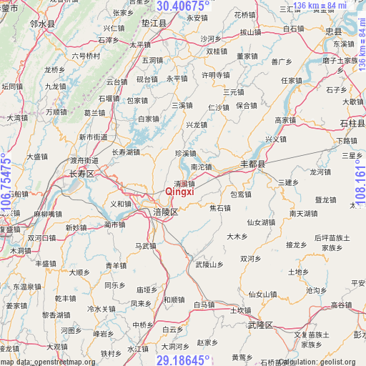
Qingxi GPS coordinates[2]
29° 47' 54.456" North, 107° 27' 28.332" East
| Map corner | latitude | longitude |
|---|---|---|
| Upper-left | 30.40675°, | 106.75475° |
| Center: | 29.79846°, | 107.45787° |
| Lower-right: | 29.18645°, | 108.161° |
| Map W x H: | 135.7×135.7 km | = 84.3×84.3mi |
| max Lat: | 53.31946° ⇑56.4% North |
| Qingxi: | 29.79846° |
| min Lat: | ⇓43.6% South 18.22056° |
| min Long | Qingxi | max Long |
| 75.07348° | 107.45787° | 134.28917° |
| W 17.7%⇐ | ⇒82.3% E |
Elevation
Elevation of Qingxi is 180 m = 591 ft, and this is 304.8 m = 1000 ft below average elevation for this country.
| Max E: |
5622 m = 18445 ft | 48.1% |
| Avg. | 484.8 m = 1591 ft | |
| Qingxi | 180 m = 591 ft | |
Min E: |
-3 m = -10 ft | 51.9% |
See also: China elevation on elevation.city.
Geographical zone
Qingxi is located in North temperate zone (between Tropic of Cancer and the Arctic Circle). Distance of this Northern Tropic circle is 707.4 km =439.6 mi to South.| Distance of | km | miles | from Qingxi |
|---|---|---|---|
| North Pole | 6693.8 | 4159.3 | to North |
| Arctic Circle | 4087.9 | 2540.1 | to North |
| Tropic Cancer | 707.4 | 439.6 | to South |
| Equator | 3313.3 | 2058.8 | to South |


Nearby cities:
15 places around Qingxi: (largest is in red/bold)
• Baisheng
6.5 km =4 mi,  284°
284°
• Conglin
13.3 km =8.3 mi,  306°
306°
• Fuling
11.9 km =7.4 mi,  210°
210°
• Jiaoshi
16.3 km =10.1 mi,  124°
124°
• Lidu
18.4 km =11.4 mi,  255°
255°
• Lizhi
12.2 km =7.6 mi, 209°
• Luoyun
13.7 km =8.5 mi,  98°
98°
• Nantuo
9.1 km =5.7 mi,  40°
40°
• Renyi
16.2 km =10.1 mi,  53°
53°
• Shilong
15.8 km =9.8 mi, 276°
• Tiantai
16 km =9.9 mi,  180°
180°
• Yunji
17.6 km =10.9 mi,  319°
319°
• Zhanpu
18 km =11.2 mi,  73°
73°
• Zhenxi
11.2 km =7 mi,  3°
3°
• Zhihan
18 km =11.2 mi,  269°
269°
Sources, notices
• [Note1] Compared only with cities in China existing in our database
• [Src1] Map data: © OpenStreetMap contributors (CC-BY-SA)
• [Src2] Other city data from geonames.org with taken over terms of usage.
• [Src3] Geographical zone / Annual Mean Temperature by Robert A. Rohde @ Wikipedia
