Fanzhuang geodata
Fanzhuang (Tianjin) is a populated place; located in China in Asia/Shanghai (GMT+8) time zone. With population of 6,493 people, there are 845 cities with bigger population in this country. Compared to other cities in China, 83.7% of cities are located further ↓South; 68% of cities are located further ←West and 98.3% of cities have higher elevation than Fanzhuang. Note1


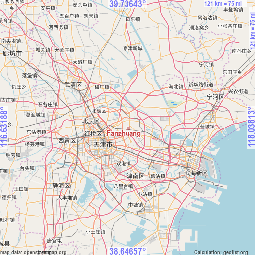
Fanzhuang GPS coordinates[2]
39° 11' 36.996" North, 117° 20' 6" East
| Map corner | latitude | longitude |
|---|---|---|
| Upper-left | 39.73643°, | 116.63188° |
| Center: | 39.19361°, | 117.335° |
| Lower-right: | 38.64657°, | 118.03813° |
| Map W x H: | 121.2×121.2 km | = 75.3×75.3mi |
| max Lat: | 53.31946° ⇑16.3% North |
| Fanzhuang: | 39.19361° |
| min Lat: | ⇓83.7% South 18.22056° |
| min Long | Fanzhuang | max Long |
| 75.07348° | 117.335° | 134.28917° |
| W 68%⇐ | ⇒32% E |
Elevation
Elevation of Fanzhuang is 4 m = 13 ft, and this is 480.8 m = 1577 ft below average elevation for this country.
| Max E: |
5622 m = 18445 ft | 98.3% |
| Avg. | 484.8 m = 1591 ft | |
| Fanzhuang | 4 m = 13 ft | |
Min E: |
-3 m = -10 ft | 1.7% |
See also: China elevation on elevation.city.
Geographical zone
Fanzhuang is located in North temperate zone (between Tropic of Cancer and the Arctic Circle). Distance of this Northern Tropic circle is 1752 km =1088.6 mi to South.| Distance of | km | miles | from Fanzhuang |
|---|---|---|---|
| North Pole | 5649.1 | 3510.2 | to North |
| Arctic Circle | 3043.3 | 1891 | to North |
| Tropic Cancer | 1752 | 1088.6 | to South |
| Equator | 4357.9 | 2707.9 | to South |


Nearby cities:
15 places around Fanzhuang: (largest is in red/bold)
• Chenglin
10.2 km =6.3 mi,  210°
210°
• Chitu
5.9 km =3.7 mi,  79°
79°
• Dabizhuang
6.8 km =4.2 mi,  269°
269°
• Dongditou
8.7 km =5.4 mi,  21°
21°
• Dongxin
8 km =5 mi,  223°
223°
• Huaming
4.1 km =2.5 mi, 209°
• Huangcaotuo
2 km =1.2 mi, 216°
• Huantuo
3.8 km =2.4 mi,  345°
345°
• Jianchangdao
10.1 km =6.3 mi,  254°
254°
• Jiangdulu
9.2 km =5.7 mi,  243°
243°
• Liukuaizhuang
6 km =3.7 mi,  3°
3°
• Shangkenglu
10.2 km =6.3 mi, 223°
• Xiditou
6.8 km =4.2 mi,  9°
9°
• Yueyahe
8.8 km =5.5 mi, 246°
• Zhaoguli
8.6 km =5.3 mi, 249°
Sources, notices
• [Note1] Compared only with cities in China existing in our database
• [Src1] Map data: © OpenStreetMap contributors (CC-BY-SA)
• [Src2] Other city data from geonames.org with taken over terms of usage.
• [Src3] Geographical zone / Annual Mean Temperature by Robert A. Rohde @ Wikipedia
