Chitu geodata
Chitu (Tianjin) is a populated place; located in China in Asia/Shanghai (GMT+8) time zone. With population of 8,939 people, there are 820 cities with bigger population in this country. Compared to other cities in China, 83.7% of cities are located further ↓South; 68.3% of cities are located further ←West and 99.7% of cities have higher elevation than Chitu. Note1


Chitu GPS coordinates[2]
39° 12' 11.988" North, 117° 24' 10.008" East
| Map corner | latitude | longitude |
|---|---|---|
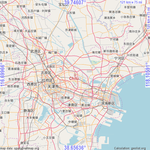
| Upper-left | 39.74607°, | 116.69966° |
| Center: | 39.20333°, | 117.40278° |
| Lower-right: | 38.65636°, | 118.10591° |
| Map W x H: | 121.2×121.2 km | = 75.3×75.3mi |
| max Lat: | 53.31946° ⇑16.3% North |
| Chitu: | 39.20333° |
| min Lat: | ⇓83.7% South 18.22056° |
| min Long | Chitu | max Long |
| 75.07348° | 117.40278° | 134.28917° |
| W 68.3%⇐ | ⇒31.7% E |
Elevation
Elevation of Chitu is 1 m = 3 ft, and this is 483.8 m = 1587 ft below average elevation for this country.
| Max E: |
5622 m = 18445 ft | 99.7% |
| Avg. | 484.8 m = 1591 ft | |
| Chitu | 1 m = 3 ft | |
Min E: |
-3 m = -10 ft | 0.3% |
See also: China elevation on elevation.city.
Geographical zone
Chitu is located in North temperate zone (between Tropic of Cancer and the Arctic Circle). Distance of this Northern Tropic circle is 1753.1 km =1089.3 mi to South.| Distance of | km | miles | from Chitu |
|---|---|---|---|
| North Pole | 5648.1 | 3509.6 | to North |
| Arctic Circle | 3042.2 | 1890.3 | to North |
| Tropic Cancer | 1753.1 | 1089.3 | to South |
| Equator | 4359 | 2708.6 | to South |


Nearby cities:
15 places around Chitu: (largest is in red/bold)
• Dabizhuang
12.7 km =7.9 mi,  264°
264°
• Dawangtai
10.7 km =6.6 mi,  41°
41°
• Dongditou
7.5 km =4.7 mi,  339°
339°
• Dongxin
13.3 km =8.3 mi,  238°
238°
• Fanzhuang
5.9 km =3.7 mi, 259°
• Huaming
9.1 km =5.7 mi, 239°
• Huangcaotuo
7.5 km =4.7 mi,  249°
249°
• Huantuo
7.3 km =4.5 mi,  290°
290°
• Huozhuangzi
12.5 km =7.8 mi,  321°
321°
• Liukuaizhuang
7.4 km =4.6 mi,  312°
312°
• Luotuofangzi
13.5 km =8.4 mi,  189°
189°
• Xiditou
7.3 km =4.5 mi, 319°
• Xinli
14.4 km =8.9 mi,  203°
203°
• Yaoliuqiao
11.6 km =7.2 mi, 189°
• Zaojiacheng
8.7 km =5.4 mi,  19°
19°
Sources, notices
• [Note1] Compared only with cities in China existing in our database
• [Src1] Map data: © OpenStreetMap contributors (CC-BY-SA)
• [Src2] Other city data from geonames.org with taken over terms of usage.
• [Src3] Geographical zone / Annual Mean Temperature by Robert A. Rohde @ Wikipedia
