Fangshan geodata
Fangshan (Beijing) is a populated place; located in China in Asia/Shanghai (GMT+8) time zone. With population of 97,026 people, there are 438 cities with bigger population in this country. Compared to other cities in China, 85.3% of cities are located further ↓South; 60.1% of cities are located further ←West and 73% of cities have higher elevation than Fangshan. Note1


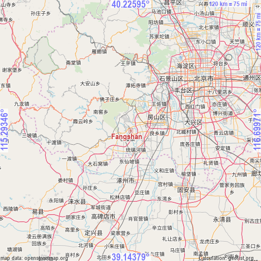
Fangshan GPS coordinates[2]
39° 41' 13.164" North, 115° 59' 47.688" East
| Map corner | latitude | longitude |
|---|---|---|
| Upper-left | 40.22595°, | 115.29346° |
| Center: | 39.68699°, | 115.99658° |
| Lower-right: | 39.14379°, | 116.69971° |
| Map W x H: | 120.3×120.3 km | = 74.8×74.8mi |
| max Lat: | 53.31946° ⇑14.7% North |
| Fangshan: | 39.68699° |
| min Lat: | ⇓85.3% South 18.22056° |
| min Long | Fangshan | max Long |
| 75.07348° | 115.99658° | 134.28917° |
| W 60.1%⇐ | ⇒39.9% E |
Elevation
Elevation of Fangshan is 42 m = 138 ft, and this is 442.8 m = 1453 ft below average elevation for this country.
| Max E: |
5622 m = 18445 ft | 73% |
| Avg. | 484.8 m = 1591 ft | |
| Fangshan | 42 m = 138 ft | |
Min E: |
-3 m = -10 ft | 27% |
See also: Fangshan elevation on elevation.city.
Geographical zone
Fangshan is located in North temperate zone (between Tropic of Cancer and the Arctic Circle). Distance of this Northern Tropic circle is 1806.9 km =1122.8 mi to South.| Distance of | km | miles | from Fangshan |
|---|---|---|---|
| North Pole | 5594.3 | 3476.1 | to North |
| Arctic Circle | 2988.4 | 1856.9 | to North |
| Tropic Cancer | 1806.9 | 1122.8 | to South |
| Equator | 4412.8 | 2742 | to South |


Nearby cities:
15 places around Fangshan: (largest is in red/bold)
• Beizang
24.7 km =15.3 mi,  93°
93°
• Changgou
15.3 km =9.5 mi,  214°
214°
• Dashiwo
21.5 km =13.4 mi,  226°
226°
• Gongchen
12.9 km =8 mi,  69°
69°
• Hebei
15.3 km =9.5 mi,  338°
338°
• Liangxiang
12.9 km =8 mi,  64°
64°
• Liulihe
10.5 km =6.5 mi,  163°
163°
• Nanjiao
15.9 km =9.9 mi,  302°
302°
• Qinglonghu
10.1 km =6.3 mi,  18°
18°
• Tanzhesi
20.8 km =12.9 mi,  7°
7°
• Wangzuo
19.1 km =11.9 mi,  45°
45°
• Xiangyang
7 km =4.3 mi,  330°
330°
• Xiayunling
22.6 km =14 mi,  280°
280°
• Zhangfang
27.9 km =17.3 mi,  242°
242°
• Zhoukoudian
5.3 km =3.3 mi,  266°
266°
Sources, notices
• [Note1] Compared only with cities in China existing in our database
• [Src1] Map data: © OpenStreetMap contributors (CC-BY-SA)
• [Src2] Other city data from geonames.org with taken over terms of usage.
• [Src3] Geographical zone / Annual Mean Temperature by Robert A. Rohde @ Wikipedia
